Back Coronel Fabriciano AN Coronel Fabriciano ANG كورونيل فابريسيانو Arabic Coronel Fabriciano BCL কোরোনেল ফাব্রিসিয়ানো BPY Coronel Fabriciano Breton Coronel Fabriciano Catalan Coronel Fabriciano CBK-ZAM Коронел-Фабрисиану CE Coronel Fabriciano (munisipyo) CEB
Coronel Fabriciano | |
|---|---|
Municipality | |
| The Municipality of Coronel Fabriciano | |
 Partial view of Coronel Fabriciano seen from Timóteo | |
| Nicknames: "Fabri" "Fabriciano" "Terra mãe do Vale do Aço" | |
| Motto(s): Deus, Pax Et Prosperitas, Deus, Paz e Prosperidade God, Peace and Prosperity | |
 | |
| Coordinates: 19°31′08″S 42°37′44″W / 19.51889°S 42.62889°W | |
| Country | |
| Region | Southeast |
| State | Minas Gerais |
| Founded | January 20, 1949 |
| Government | |
| • Mayor | Marcos Vinícius da Silva Bizarro (PSDB) |
| Area | |
| • Total | 221.252 km2 (85.426 sq mi) |
| [1] | |
| Elevation | 250 m (820 ft) |
| Population (2020) | |
| • Total | 110,290 |
| • Density | 498.5/km2 (1,291/sq mi) |
| IBGE[2] | |
| Demonym | Fabricianense |
| Time zone | UTC-3 (UTC-3) |
| Postal Code | 35170-000 |
| HDI (2010) | 0.755 – high |
| Website | www |
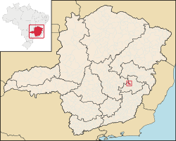
Coronel Fabriciano is a municipality in the state of Minas Gerais in the Southeast region of Brazil. It is located in the region of Vale do Rio Doce and is situated 200 km from the state capital. The municipal population was estimated in 2020 by IBGE in 110,290 inhabitants.[2] The area is 221.252 km2 (85.426 sq mi) (13.1549 km2 (5.0791 sq mi) of urban area).[1][3]
The municipality was emancipated from Antônio Dias in 1948 and its name is a tribute to Lieutenant colonel Fabriciano Felisberto Carvalho de Brito.[4] The town was situated in the Vale do Aço (Steel Valley) metropolitan area, between the largest steel industries of Minas Gerais state; Usiminas, in Ipatinga, and the Aperam South America, in Timóteo. These industries were situated in Fabriciano at they time they were constructed, and were essential to the development of the city. However, these facilities are located within the area of Ipatinga and Timóteo respectively, which were emancipated from Coronel Fabricano, and incorporated proper in 1964.[5]
Coronel Fabriciano is located in the Serra dos Cocais, home of many natural attractions of the city like the "Pedra Dois Irmãos" (Two Brothers stone), the "Pedra do Caladão" (Silent stone), the "Cachoeira do Escorregador" (slide waterfalls), the "Trilhas da Mamucha" (Mamucha trails), and other waterfalls and trails. Outdoor sports are popular such as hiking, trekking, mountain biking, parachute jumping, and 4x4 offroading. The city also features historical monuments like the "Catedral de São Sebastião" (Saint Sebastian Cathedral), the "Colégio Angélica" (Angélica College) and the "Monumento Terra Mãe" (motherland monument).[6][7]
The Human Development Index (HDI) is 0.755, classified as high by the United Nations Development Programme (UNDP).[8]
- ^ a b Instituto Brasileiro de Geografia e Estatística (IBGE) (January 15, 2013). "Área territorial oficial" (in Portuguese). Archived from the original on June 23, 2017. Retrieved June 23, 2017.
- ^ a b Instituto Brasileiro de Geografia e Estatística (IBGE). "Coronel Fabriciano" (in Portuguese). Archived from the original on September 6, 2020. Retrieved February 20, 2019.
- ^ Embrapa Monitoramento por Satélite. "Minas Gerais" (in Portuguese). Archived from the original on July 30, 2013. Retrieved February 25, 2013.
- ^ Revista Caminhos Gerais, number 18, page 7
- ^ Prefeitura (June 3, 2009). "A criação do município" (in Portuguese). Archived from the original on July 30, 2013. Retrieved February 25, 2013.
- ^ Prefeitura (March 1, 2012). "Patrimônio Cultural" (in Portuguese). Archived from the original on October 8, 2014. Retrieved February 25, 2013.
- ^ Prefeitura (August 7, 2009). "Sugestão de passeios: roteiro para o meio urbano" (in Portuguese). Archived from the original on July 31, 2013. Retrieved February 25, 2013.
- ^ Atlas do Desenvolvimento Humano, Programa das Nações Unidas para o Desenvolvimento (PNUD) (July 29, 2013). "Ranking decrescente do IDH-M dos municípios do Brasil" (PDF) (in Portuguese). Archived from the original (PDF) on October 13, 2013. Retrieved June 23, 2017.


