Back كروكير (جزيره) ARZ Croker Island (pulo sa Ostralya) CEB Croker Island (Northern Territory) German Île Croker French Croker Island Italian კროკერი (კუნძული) Georgian Croker Island Polish Крокер (остров) Russian Croker Island (ö i Australien) Swedish
Native name: Margo | |
|---|---|
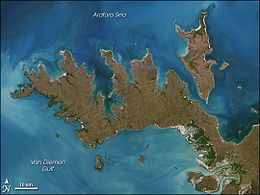
 Image of Croker Island with Cobourg Peninsula | |
| Geography | |
| Location | Arafura Sea |
| Coordinates | 11°08′S 132°33′E / 11.133°S 132.550°E |
| Major islands | Croker, Darch, Templer |
| Area | 331.5 km2 (128.0 sq mi) |
| Length | 43 km (26.7 mi) |
| Width | 15 km (9.3 mi) |
| Highest elevation | 15 m (49 ft) |
| Administration | |
Australia | |
| Territory | Northern Territory |
| Shire | West Arnhem Region |
| Ward | Barrah Ward |
| Largest settlement | Minjilang (pop. 271) |
| Demographics | |
| Population | 300 |
| Pop. density | 0.9/km2 (2.3/sq mi) |
Croker Island is an island in the Arafura Sea off the coast of the Northern Territory, Australia, 250 km (160 mi) northeast of Darwin. It was the site of the Croker Island Mission between 1940 and 1968.
