Back كرومبرغ (كاليفورنيا) Arabic کرومبرق، کالیفورنیا AZB Cromberg Catalan Кромберг (Калифорни) CE Cromberg CEB Cromberg Spanish Cromberg (Kalifornia) Basque کرومبرگ، کالیفرنیا Persian Cromberg French Cromberg (Kalifornija) Croatian
Cromberg | |
|---|---|
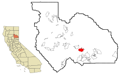
 Location in Plumas County and the state of California | |
| Coordinates: 39°52′7″N 120°42′25″W / 39.86861°N 120.70694°W | |
| Country | |
| State | |
| County | Plumas |
| Area | |
| • Total | 9.03 sq mi (23.39 km2) |
| • Land | 9.03 sq mi (23.39 km2) |
| • Water | 0.00 sq mi (0.00 km2) 0% |
| Elevation | 4,285 ft (1,306 m) |
| Population (2020) | |
| • Total | 272 |
| • Density | 30.13/sq mi (11.63/km2) |
| Time zone | UTC-8 (Pacific (PST)) |
| • Summer (DST) | UTC-7 (PDT) |
| ZIP code | 96103 |
| Area code | 530 |
| FIPS code | 06-17288 |
| GNIS feature IDs | 1658353; 2407684 |
| U.S. Geological Survey Geographic Names Information System: Cromberg, California; U.S. Geological Survey Geographic Names Information System: Cromberg, California | |
Cromberg (formerly, Twenty-Mile House,[2] Taft,[2] and Teft[3]) is a census-designated place (CDP) in Plumas County, California, United States. Cromberg is located on the Western Pacific Railroad, 6.5 miles (10.5 km) northwest of Blairsden.[3] The population was 261 at the 2010 census, down from 290 at the 2000 census.
- ^ "2020 U.S. Gazetteer Files". United States Census Bureau. Retrieved October 30, 2021.
- ^ a b c U.S. Geological Survey Geographic Names Information System: Cromberg, California
- ^ a b Durham, David L. (1998). California's Geographic Names: A Gazetteer of Historic and Modern Names of the State. Clovis, Calif.: Word Dancer Press. p. 369. ISBN 1-884995-14-4.
