Cumberland Highway (numerous constituent roads) | |
|---|---|
 | |
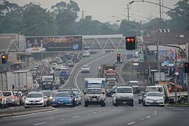
| Cumberland Highway as Pennant Hills Road at Thornleigh in 2016 | |
| Coordinates |
|
| General information | |
| Type | Highway |
| Length | 34.2 km (21 mi)[1] |
| Gazetted | August 1928 (as Main Road 13, Pennant Hills Road)[2] August 1988 (as State Highway 13, Cumberland Highway)[3] |
| Route number(s) |
|
| Former route number |
|
| Major junctions | |
| Northeast end | Wahroonga, Sydney |
| Southwest end | Liverpool, Sydney |
| Highway system | |
| ---- | |
Cumberland Highway is a 34-kilometre (21 mi) long[1] urban highway located in Sydney, New South Wales, Australia. The highway links Pacific Highway and Pacific Motorway (M1) at Pearces Corner, Wahroonga in the northeast with Hume Highway at Liverpool in the southwest. This name covers a few consecutive roads and is widely known to most drivers, but the entire allocation is also known – and signposted – by the names of its constituent parts: Pennant Hills Road, James Ruse Drive, Briens Road, Old Windsor Road, Hart Drive, Freame Street, Emert Street, Jersey Road, Betts Road, Warren Road, Smithfield Road, Palmerston Road, (New) Cambridge Street, Joseph Street and Orange Grove Road. The entire length of Cumberland Highway is designated part of route A28.
The name of the highway is derived from the Cumberland Plain and Cumberland County. The name Cumberland was conferred on the county by Governor Arthur Phillip in honour of Ernest Augustus, Duke of Cumberland.[4]
- ^ a b "Cumberland Highway" (Map). Google Maps. Retrieved 16 January 2023.
- ^ "Main Roads Act, 1924-1927". Government Gazette of the State of New South Wales. No. 110. 17 August 1928. pp. 3814–20. Archived from the original on 3 August 2022. Retrieved 1 August 2022 – via National Library of Australia.
- ^ "State Roads Act". Government Gazette of the State of New South Wales. No. 138. 26 August 1988. p. 4505. Archived from the original on 16 January 2023. Retrieved 16 January 2023 – via National Library of Australia.
- ^ "Cumberland". Geographical Names Register (GNR) of NSW. Geographical Names Board of New South Wales. Retrieved 4 August 2013.

