Back Custer State Park CEB Custer State Park German Parc d'État de Custer French Custer State Park Italian Custer State Park NB Park stanowy Custer Polish
| Custer State Park | |
|---|---|
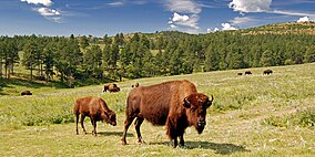
 American bison at the Wildlife Loop Road | |
| Location | Custer County, South Dakota, United States |
| Coordinates | 43°44′45″N 103°25′5″W / 43.74583°N 103.41806°W |
| Area | 71,000 acres (290 km2) |
| Elevation | 4,721 ft (1,439 m)[1] |
| Established | 1912 |
| Named for | George Armstrong Custer |
| Governing body | South Dakota Department of Game, Fish & Parks (GFP) |
  |
| Southwestern South Dakota |
|---|
| Sculptures |
| Geologic and natural history |
| Mountains |
| Caves |
| Forests and wildernesses |
| Lakes |
| Scenic byways |
| Historic sites |
Custer State Park is a South Dakota State Park and wildlife reserve in the Black Hills of the United States. Located in Custer County, the park is South Dakota's first and largest state park, named after Lieutenant Colonel George Armstrong Custer. The park covers an area of over 71,000 acres (287 km2) of varied terrain including rolling prairie grasslands and rugged mountains.[2]
The park is home to a herd of 1,500 bison.[3][2] Elk, coyotes, mule deer, white tailed deer, mountain goats, prairie dogs, bighorn sheep, river otters, pronghorn, cougars, and feral burros also inhabit the park. The park is known for its scenery, its scenic drives (Needles Highway and the wildlife loop), with views of the bison herd and prairie dog towns. This park is easily accessible by road from Rapid City. Other nearby attractions are Wind Cave National Park, Mount Rushmore, Jewel Cave National Monument, Crazy Horse Memorial, and Badlands National Park.
- ^ "Custer State Park". Geographic Names Information System. United States Geological Survey. February 13, 1980. Retrieved February 28, 2011.
- ^ a b "Custer State Park". Archived from the original on October 24, 2007. Retrieved October 18, 2007.
- ^ Bonnet, Siandhara (August 30, 2021). "Woman tossed by bison at Custer State Park". Billings Gazette. Archived from the original on August 31, 2021. Retrieved August 31, 2021.
