Back دمبل (ایتالیا) AZB Дамбель Byelorussian Дамбел Bulgarian Dambel Breton Dambel Catalan Дамбель CE Dambel (munisipyo) CEB Dambel German Ντάμπελ Greek Dambel Esperanto
Dambel | |
|---|---|
| Comune di Dambel | |
| Coordinates: 46°24′N 11°6′E / 46.400°N 11.100°E | |
| Country | Italy |
| Region | Trentino-Alto Adige/Südtirol |
| Province | Trentino (TN) |
| Government | |
| • Mayor | Carlo Polastri |
| Area | |
| • Total | 5.1 km2 (2.0 sq mi) |
| Elevation | 750 m (2,460 ft) |
| Population (Dec. 2004)[2] | |
| • Total | 436 |
| • Density | 85/km2 (220/sq mi) |
| Demonym | Dambellesi |
| Time zone | UTC+1 (CET) |
| • Summer (DST) | UTC+2 (CEST) |
| Postal code | 38010 |
| Dialing code | 0463 |
| Patron saint | Santa Maria Assunta |
| Saint day | August 15 |
| Website | Official website |

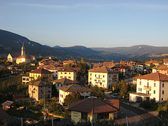
Dambel (Nones: Dambel; Latin: Ambulum) is a comune (municipality) in Trentino in the northern Italian region Trentino-Alto Adige/Südtirol, located about 35 kilometres (22 mi) north of the city of Trento.
Dambel is located in the Val di Non at an elevation of 750 metres (2,460 ft). It is on the provincial highway between Sanzeno to the south and Sarnonico to the north. The town's name derives from the Latin word ambulum because it was at an historical crossroads on the commercial road between Lombardy and Germany, which crossed through Dambel and over the Novella River at the Pozzena bridge. Today the economy of Dambel is concentrated on the production of apples.
- ^ "Superficie di Comuni Province e Regioni italiane al 9 ottobre 2011". Italian National Institute of Statistics. Retrieved 16 March 2019.
- ^ "Popolazione Residente al 1° Gennaio 2018". Italian National Institute of Statistics. Retrieved 16 March 2019.


