Back دارلینقتون، مریلند AZB Darlington (lungsod sa Tinipong Bansa, Maryland) CEB Darlington (Maryland) Spanish دارلینگتن، مریلند Persian Darlington (Maryland) LLD Darlington (Maryland) Polish Darlington, Maryland Serbo-Croatian Дарлингтон (Мериленд) Serbian Darlington, Maryland Swedish Дарлингтон (Мэриленд) Tatar
Darlington, Maryland | |
|---|---|
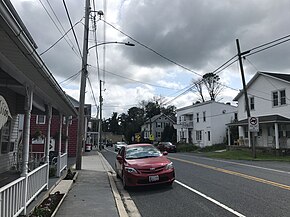
 Downtown Darlington (August 2021) | |
| Coordinates: 39°38′21″N 76°12′10″W / 39.63917°N 76.20278°W | |
| Country | United States |
| State | Maryland |
| County | Harford |
| Area | |
| • Total | 1.04 sq mi (2.71 km2) |
| • Land | 1.04 sq mi (2.71 km2) |
| • Water | 0.00 sq mi (0.00 km2) |
| Elevation | 330 ft (100 m) |
| Population (2020) | |
| • Total | 398 |
| • Density | 380.86/sq mi (147.02/km2) |
| Time zone | UTC−5 (Eastern (EST)) |
| • Summer (DST) | UTC−4 (EDT) |
| ZIP code | 21034[2] |
| Area code(s) | 410 and 443 and 667 |
| FIPS code | 24-21800 |
Darlington is an unincorporated community and census-designated place in northeastern Harford County, Maryland, United States.[3] The population was 409 at the 2010 census.[4] The center of the community was listed on the National Register of Historic Places as the Darlington Historic District in 1987. Median household income is $66,563. The percentage of people in poverty is 5.3%.
- ^ "2020 U.S. Gazetteer Files". United States Census Bureau. Retrieved April 26, 2022.
- ^ "Darlington MD ZIP Code". zipdatamaps.com. 2023. Retrieved April 18, 2023.
- ^ The Darlington Apple Festival Archived 2005-12-30 at the Wayback Machine, Darlington Apple Festival. Accessed 2007-11-26.
- ^ "Geographic Identifiers: 2010 Demographic Profile Data (G001): Darlington CDP, Maryland". American Factfinder. U.S. Census Bureau. Retrieved July 13, 2017.[dead link]

