Back Taman Nasional De Biesbosch BAN Národní park De Biesbosch Czech Nationalpark De Biesbosch German Parc national De Biesbosch French Nasjonaal Park De Biisbosk Frisian Parco nazionale De Biesbosch Italian ბისბოსხის ეროვნული პარკი Georgian Nationaal Park De Biesbosch Dutch Parque Nacional De Biesbosch Portuguese Biesbosch Swedish
This article needs additional citations for verification. (May 2009) |
| De Biesbosch National Park | |
|---|---|
| Nationaal Park De Biesbosch | |
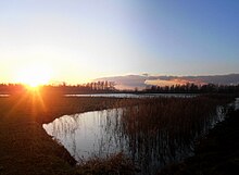
 Hollandse Biesbosch near Dordrecht, Netherlands | |
 Map of the National Park | |
| Location | Municipalities: Altena, Dordrecht, Drimmelen, Geertruidenberg Provinces: North Brabant, South Holland Country: Netherlands |
| Nearest city | Dordrecht, Netherlands |
| Coordinates | 51°44′N 4°45′E / 51.733°N 4.750°E |
| Area | 90 km2 (35 sq mi) |
| Established | 1994 |
| Governing body | Staatsbosbeheer |
| www | |
| Official name | Biesbosch |
| Designated | 23 May 1980 |
| Reference no. | 197[1] |


De Biesbosch National Park is one of the largest national parks in the Netherlands[2] and one of the last extensive areas of freshwater tidal wetlands in Northwestern Europe. The Biesbosch ('forest of sedges' or 'rushwoods') consists of a large network of rivers and smaller and larger creeks with islands. The vegetation is mostly willow forests, although wet grasslands and fields of reed are common as well.[3] The Biesbosch is an important wetland area for waterfowl and has a rich flora and fauna. It is especially important for migrating geese.
- ^ "Biesbosch". Ramsar Sites Information Service. Retrieved 25 April 2018.
- ^ "Samenwerkingsverband Nationale Parken" (in Dutch).
- ^ "Planten in de Biesbosch" (in Dutch). Archived from the original on 2014-10-16.