Deep River (North Carolina)

Deep River
Tributary to Cape Fear River
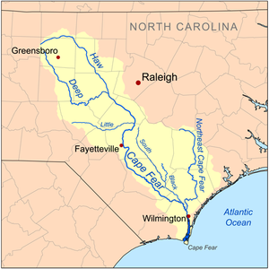
Map of the Cape Fear drainage basin showing Deep River
Location
CountryUnited States
StateNorth Carolina
CountiesChatham
Guilford
Lee
Moore
Randolph
CitiesRamseur
Franklinville
Randleman
Physical characteristics
Sourceconfluence of West and East Fork of Deep River
 • locationHigh Point, North Carolina[1]
 • coordinates35°59′44″N 079°56′44″W / 35.99556°N 79.94556°W / 35.99556; -79.94556[2]
 • elevation757 ft (231 m)
MouthCape Fear River
 • location
Moncure, North Carolina[1]
 • coordinates
35°35′48″N 079°03′11″W / 35.59667°N 79.05306°W / 35.59667; -79.05306[2]
 • elevation
160 ft (49 m)
Length112.97 mi (181.81 km)[3]
Basin size1,450.17 square miles (3,755.9 km2)
Discharge 
 • locationCape Fear River
 • average1,525.72 cu ft/s (43.204 m3/s) at mouth with Cape Fear River[4]
Basin features
ProgressionCape Fear RiverAtlantic Ocean
River systemCape Fear River
Tributaries 
 • leftEast Fork of Deep River
Bull Run
Hickory Creek
Polecat Creek
Bush Creek
Sandy Creek
Reed Creek
Millstone Creek
Broad Mouth Branch
Back Branch
Brush Creek
Flat Creek
Cedar Creek
Falls Creek
Tysons Creek
Line Creek
Indian Creek
Cedar Creek
Georges Creek
Rocky River
Rocky Branch
 • rightWest Fork Deep River
Copper Branch
Richland Creek
Muddy Creek
Hasketts Creek
Gabriels Creek
Mill Creek
Richland Creek
Fork Creek
Grassy Creek
Bear Creek
Buffalo Creek
Scotchman Creek
Lick Creek
McLendons Creek
Big Governors Creek
Smiths Creek
Pocket Creek
Patterson Creek
Big Buffalo Creek
Little Buffalo Creek
WaterbodiesHigh Point Lake

Deep River is a tributary of the Cape Fear River, approximately 125 miles (201 km) long, in north central North Carolina in the United States. Deep River is a translation of the Indian name sapponah, "deep river".[5]

Paddling is popular on the river. Deep River is flanked by the planned Deep River State Trail and several other parks and preservation areas including Carbonton Dam Park, House in the Horseshoe Historic Site, Deep River Park and Deep River Camelback Truss Bridge, Endor Iron Furnace, White Pines Nature Preserve, Lockville Dam, Canal and Powerhouse, and Mermaid Point.[6]

The Cape Fear shiner, a critically endangered minnow, inhabits the river.

  1. ^ a b "Deep River Topo Map, Chatham County NC (Moncure Area)". TopoZone. Locality, LLC. Retrieved 25 July 2019.
  2. ^ a b "GNIS Detail - Deep River". geonames.usgs.gov. US Geological Survey. Retrieved 25 July 2019.
  3. ^ "ArcGIS Web Application". epa.maps.arcgis.com. US EPA. Retrieved 25 July 2019.
  4. ^ "Deep River Watershed Report". Waters Geoviewer. US EPA. Retrieved 25 July 2019.
  5. ^ Gannett, Henry (1905). The Origin of Certain Place Names in the United States. Govt. Print. Off. pp. 102.
  6. ^ "Deep River Paddling Guide" (PDF). Archived from the original (PDF) on 2014-10-12. Retrieved 2013-04-07.

From Wikipedia, the free encyclopedia · View on Wikipedia

Developed by Tubidy