Deh Cho Bridge | |
|---|---|
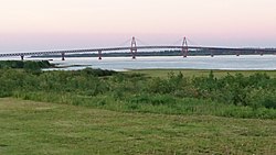
 Deh Cho Bridge in 2016 | |
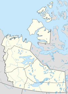
| Coordinates | 61°15′45″N 117°31′30″W / 61.26250°N 117.52500°W |
| Carries | 2 lanes of Highway 3 |
| Crosses | Mackenzie River |
| Locale | Fort Providence |
| Official name | Deh Cho Bridge |
| Owner | Government of the Northwest Territories |
| Characteristics | |
| Design | Truss bridge Cable-stayed main span |
| Total length | 1.1 km (0.68 mi) |
| Longest span | 190 m (623 ft) |
| No. of spans | 9 |
| Piers in water | 8 |
| Design life | 75 years |
| History | |
| Construction start | June 2008 |
| Construction cost | Can$202 million[1] |
| Opened | November 30, 2012[2] |
| Location | |
The Deh Cho Bridge is a 1.1 km-long (0.68 mi) cable-stayed bridge across a 1.6 km (0.99 mi) span of the Mackenzie River on the Yellowknife Highway (Highway 3) near Fort Providence, Northwest Territories. Construction began in 2008 and was expected to be completed in 2010 but faced delays due to technical and financial difficulties. The bridge officially opened to traffic on November 30, 2012.[2] The bridge replaced the MV Merv Hardie, the ferry in operation at the time of opening, and ice bridge combination used for river crossing.
Deh Cho (lit. "Big River") is the Slavey language name for the Mackenzie River.[3]
- ^ Green, Jeff (November 29, 2012). "Deh Cho Bridge ends North's reliance on ice road". Toronto Star. Retrieved November 30, 2012.
- ^ a b "Deh Cho Bridge to open Nov. 30". CBC News. November 6, 2012. Retrieved November 8, 2012.
- ^ John Allemang (2012-12-03). "'We're finally connected to the rest of Canada': NWT residents celebrate Deh Cho bridge". The Globe and Mail. Retrieved 2013-05-09.


