Back Deniliquin (rehiyon) CEB Deniliquin Council German Conseil de Deniliquin French Municipalità di Deniliquin Italian Deniliquin Council Dutch Deniliquin Council Swedish
| Deniliquin Council New South Wales | |||||||||||||||
|---|---|---|---|---|---|---|---|---|---|---|---|---|---|---|---|
 Town hall | |||||||||||||||
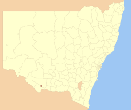
 Location in New South Wales | |||||||||||||||
| Coordinates | 35°32′S 144°58′E / 35.533°S 144.967°E | ||||||||||||||
| Population | 7,327 (2012)[1] | ||||||||||||||
| • Density | 51.166/km2 (132.52/sq mi) | ||||||||||||||
| Established | 16 December 1868 | ||||||||||||||
| Abolished | 12 May 2016 | ||||||||||||||
| Area | 143.2 km2 (55.3 sq mi) | ||||||||||||||
| Mayor | Cr. Lindsay Renwick (Independent)[2] | ||||||||||||||
| Council seat | Deniliquin | ||||||||||||||
| Region | Riverina | ||||||||||||||
| State electorate(s) | Murray | ||||||||||||||
| Federal division(s) | Farrer | ||||||||||||||
| Website | Deniliquin Council | ||||||||||||||
| |||||||||||||||
Deniliquin Council was a local government area in the Riverina region of south-western New South Wales, Australia. At the date of its abolition, Deniliquin Council was the last rural local government area in New South Wales left consisting only of a rural town.[citation needed]
Deniliquin Council was proclaimed as the Municipality of Deniliquin on 16 December 1868.[3]
- ^ "3218.0 - Regional Population Growth, Australia, 2012". Australian Bureau of Statistics. 30 August 2013. Retrieved 27 March 2014. Estimated resident population (ERP) at 30 June 2012.
- ^ Cite error: The named reference
mayorwas invoked but never defined (see the help page). - ^ "Proclamation (309)". Government Gazette of the State of New South Wales. 19 December 1868. p. 4573. Retrieved 3 January 2020 – via National Library of Australia.