Back دينيو Arabic دينيو (منطقه فى امريكا) ARZ دنیو، نوادا AZB Denio (Nevada) Spanish دینیو، نوادا Persian Denio French Denio, Nevada HT Denio Hungarian Denio Italian Tsʼahtah Ahiʼdiitiin NV
Denio, Nevada | |
|---|---|
 | |
| Coordinates: 41°59′24″N 118°37′59″W / 41.99000°N 118.63306°W | |
| Country | United States |
| States | Nevada (CDP) Oregon (outside CDP) |
| Counties | Humboldt (CDP) Harney (outside CDP) |
| Area | |
| • Total | 0.46 sq mi (1.19 km2) |
| • Land | 0.46 sq mi (1.19 km2) |
| • Water | 0.00 sq mi (0.00 km2) |
| Elevation | 4,206 ft (1,282 m) |
| Population (2020) | |
| • Total | 34 |
| • Density | 74.24/sq mi (28.65/km2) |
| Time zone | UTC-8 (Pacific (PST)) |
| • Summer (DST) | UTC-7 (PDT) |
| ZIP code | 89404 |
| FIPS code | 32-18500 |
| GNIS feature ID | 845425[2] |
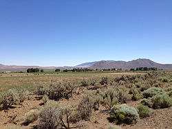
Denio is a census-designated place (CDP) in Humboldt County, Nevada, along the Oregon state line in the United States.[3] The Denio post office was originally north of the state line in Harney County, Oregon,[4] but the residents moved the building into Nevada in the mid-20th century. The population of the CDP, which is entirely in Nevada, was 47 at the 2010 census;[5] additional development considered to be Denio extends into Oregon. The CDP includes a post office, a community center, a library, and the Diamond Inn Bar, the center of the town's social life.[6] Recreational activities in the Denio area include bird watching, photography, off-road vehicle use, fishing, recreational black opal mining, rockhounding, hunting, visiting the hot springs, and camping on the Sheldon National Wildlife Refuge.[6]
Denio Junction is about 3 miles (5 km) south of Denio, at the junction of State Route 140 and State Route 292.[7] Denio Junction's motel provides gas, food, groceries, and lodging.[6] Denio Junction Airport is a two-runway graded airstrip.[8] There is no scheduled air or ground transportation serving this field, which is a short walk from Denio Junction.[8]
- ^ "ArcGIS REST Services Directory". United States Census Bureau. Retrieved September 19, 2022.
- ^ a b U.S. Geological Survey Geographic Names Information System: Denio, Nevada
- ^ "Denio". Geographic Names Information System. United States Geological Survey, United States Department of the Interior. December 12, 1980. Retrieved March 27, 2012.
- ^ "Denio Post Office (historical)". Geographic Names Information System. United States Geological Survey, United States Department of the Interior. August 1, 1994. Retrieved March 27, 2012.
- ^ "Geographic Identifiers: 2010 Demographic Profile Data (G001): Denio CDP, Nevada". U.S. Census Bureau, American Factfinder. Archived from the original on February 12, 2020. Retrieved January 24, 2013.
- ^ a b c "Denio, Nevada". travelNevada.com. Nevada Commission on Tourism. Archived from the original on February 4, 2013. Retrieved March 27, 2012.
- ^ "Denio Junction". Geographic Names Information System. United States Geological Survey, United States Department of the Interior. December 12, 1980. Retrieved March 27, 2012.

