Back ديوبري (ألبرتا) Arabic Dewberry CEB Dewberry (Alberta) French Dewberry Dutch Dewberry Swedish Д'юберрі Ukrainian
Dewberry | |
|---|---|
| Hamlet of Dewberry | |
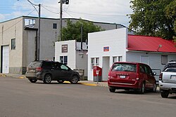
 The post office in Dewberry | |
Location in Alberta | |
| Coordinates: 53°35′09.4″N 110°31′16.2″W / 53.585944°N 110.521167°W | |
| Country | Canada |
| Province | Alberta |
| Region | Central Alberta |
| Census division | 10 |
| Municipal district | County of Vermilion River |
| Incorporated[1] | |
| • Village | January 1, 1957 |
| Dissolved[2] | January 1, 2021 |
| Area (2016)[3] | |
| • Land | 0.82 km2 (0.32 sq mi) |
| Elevation | 600 m (2,000 ft) |
| Population (2016)[3] | |
| • Total | 186 |
| • Density | 226.3/km2 (586/sq mi) |
| Time zone | UTC−7 (MST) |
| • Summer (DST) | UTC−6 (MDT) |
| Highways | Highway 45 |
| Website | Official website |
Dewberry is a hamlet in central Alberta, Canada within the County of Vermilion River.[4] It is approximately 66 km (41 mi) northwest of Lloydminster. The hamlet was named for the dewberries growing near the community.[5] Its first school opened in 1930.[6] Dewberry held village status prior to 2021.[2]
- ^ "Location and History Profile: Village of Dewberry" (PDF). Alberta Municipal Affairs. October 14, 2016. p. 232. Retrieved October 17, 2016.
- ^ a b Cite error: The named reference
dissolutionwas invoked but never defined (see the help page). - ^ a b Cite error: The named reference
2016censusABmuniswas invoked but never defined (see the help page). - ^ "Specialized and Rural Municipalities and Their Communities" (PDF). Alberta Municipal Affairs. June 3, 2024. Retrieved June 14, 2024.
- ^ Place-names of Alberta. Ottawa: Geographic Board of Canada. 1928. p. 42.
- ^ Ronaghan, Allen (1973). Earnest-Minded Men : an account of local government in the County of Vermilion River. Kitscoty, Alberta: County of Vermilion River. p. 96.
