| Donner Pass | |
|---|---|
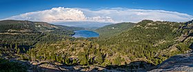
 Panorama of view to the east in July 2013 | |
| Elevation | 7,056 ft (2,151 m) |
| Traversed by | California Trail Lincoln Highway Overland Route |
| Location | Nevada County, California, United States |
| Range | Sierra Nevada |
| Coordinates | 39°18′52″N 120°19′37″W / 39.31444°N 120.32694°W[1] |
Donner Pass is a 7,056-foot-high (2,151 m)[2] mountain pass in the northern Sierra Nevada, above Donner Lake and Donner Memorial State Park about 9 miles (14 km) west of Truckee, California. Like the Sierra Nevada themselves, the pass has a steep approach from the east and a gradual approach from the west.
The pass has been used by the California Trail, First transcontinental railroad, Overland Route, Lincoln Highway and Victory Highway (both later U.S. Route 40 and still later Donner Pass Road), as well as indirectly by Interstate 80. The pass gets its name from the ill-fated Donner Party who overwintered there in 1846.
Today the area is home to a thriving recreational community with several alpine lakes and ski resorts (Donner Ski Ranch, Boreal, and Sugar Bowl). The permanent communities in the area include Kingvale and Soda Springs, as well as the larger community below the pass surrounding Donner Lake.
- ^ "Topographic map". CalTopo. Retrieved 2017-01-24.
- ^ Gannett, Henry. A Dictionary of Altitudes in the United States (3rd Edition), Bulletin of the U.S. Geological Survey, No. 160, Department of the Interior, Washington, D.C., 1899. p. 54

