Back Kuivuusrintama Finnish Front de point de rosée French ドライライン Japanese Linea sècca LMO 乾線 Chinese
The examples and perspective in this article deal primarily with the United States and do not represent a worldwide view of the subject. (March 2018) |

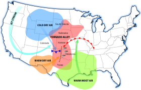
A dry line (also called a dew point line, or Marfa front, after Marfa, Texas)[1] is a line across a continent that separates moist air and dry air. One of the most prominent examples of such a separation occurs in central North America, especially Texas, Oklahoma, and Kansas, where the moist air from the Gulf of Mexico meets dry air from the desert south-western states. The dry line is an important factor in severe weather frequency in the Great Plains of North America. It typically lies north-south across the High Plains states in the warm sector of an extratropical cyclone and stretches into the Canadian Prairies during the spring and early summer.[citation needed] The dry line is also important for severe convective storms in other regions of the world, such as northern India and Southern Africa.[2] In general, thunderstorms and other forms of severe weather occur on the moist side of the dryline.
- ^ Scott Girhard (2007-05-04). "Lecture 3 - Thunderstorms". San Antonio College. Archived from the original on 2007-09-27. Retrieved 2008-03-15.
- ^ >Howard, E., and R. Washington, 2019: Drylines in Southern Africa: Rediscovering the Congo Air Boundary. J. Climate, 32, 8223–8242, https://doi.org/10.1175/JCLI-D-19-0437.1.