Back دفيل (بلجيكا) Arabic Дьофел Bulgarian Duffel Breton Duffel Catalan Duffel (parokya) CEB Duffel Czech Duffel German Duffel Esperanto Duffel Spanish Duffel Estonian
Duffel | |
|---|---|
 Duffel Town Hall | |
| Coordinates: 51°06′N 04°31′E / 51.100°N 4.517°E | |
| Country | |
| Community | Flemish Community |
| Region | Flemish Region |
| Province | Antwerp |
| Arrondissement | Mechelen |
| Government | |
| • Mayor | Sofie Joosen (N-VA) |
| • Governing party/ies | N-VA, CD&V |
| Area | |
| • Total | 22.6 km2 (8.7 sq mi) |
| Population (2020-01-01)[1] | |
| • Total | 17,664 |
| • Density | 780/km2 (2,000/sq mi) |
| Postal codes | 2570 |
| NIS code | 12009 |
| Area codes | 015, 03 |
| Website | www.duffel.be |
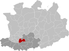
Duffel (Dutch pronunciation: [ˈdʏfəl] ) is a municipality in the Belgian province of Antwerp.
The municipality comprises the town of Duffel proper. On 1 January 2020, Duffel had a total population of 17,664. The total area is 22.71 km2 which gives a population density of 778 inhabitants per km2.
The area is the eponym of a coarse woolen cloth, manufactured in this area from the 11th century, mainly used to make blankets, outdoor (army) coats, and tote bags. Duffel became a household name during and after World War II in the meaning of a coat designed with toggle-and-loop fastening and roomy hood.[2]
The etymology of Duffel is from "dubro" and "locus", from the Gaulish dubrum, dubron – "water".
In 1836, the Duffel railway station opened on the Brussels-North to Antwerp railway line.[3]
- ^ "Bevolking per gemeente op 1 januari 2020". Statbel.
- ^ "History of the Duffel Coat". Retrieved 10 September 2022.
- ^ "L. 25 : Brussel-Noord - Antwerpen". Belgische Spoorlijnen. Retrieved 11 May 2022.


