Back دورانس (فرنسا) Arabic نهر دورانس ARZ دورانس چایی AZB Дзюранс Byelorussian Дюранс Bulgarian Durença Breton Durance BS Durance Catalan Durance (suba) CEB Durance Czech
| Durance | |
|---|---|
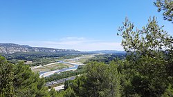
 A view of the Durance south of Cavaillon with the LGV Méditerranée viaduct | |
 | |
| Location | |
| Country | France |
| Physical characteristics | |
| Source | |
| • location | Cottian Alps |
| • elevation | 2,300 m (7,500 ft) |
| Mouth | |
• location | Rhône |
• coordinates | 43°55′21″N 4°44′35″E / 43.92250°N 4.74306°E |
| Length | 323 km (201 mi)[1] |
| Basin size | 14,472 km2 (5,588 sq mi) |
| Discharge | |
| • average | 188 m3/s (6,600 cu ft/s) |
| Basin features | |
| Progression | Rhône→ Mediterranean Sea |
The Durance (French pronunciation: [dyʁɑ̃s]; Durença in the Occitan classical norm or Durènço in the Mistralian norm) is a major river in Southeastern France. A left tributary of the Rhône, it is 323.2 km (200.8 mi) long.[1] Its drainage basin is 14,472 km2 (5,588 sq mi).[2]
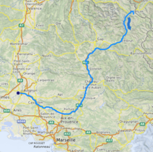
Its source is in the southwestern part of the Alps, in the Montgenèvre ski resort near Briançon; it flows southwest through the following departments and cities:
- Hautes-Alpes: Briançon, Embrun.
- Alpes-de-Haute-Provence: Sisteron, Manosque.
- Vaucluse: Cavaillon, Avignon.
- Bouches-du-Rhône.
The Durance's largest tributary is the Verdon.[1] The Durance itself is a tributary of the Rhône and flows into the Rhône near Avignon. The Durance is the second longest (after the Saône) of the tributaries of the Rhône and the third largest in terms of its flow (after the Saône and Isère).
- ^ a b c Sandre. "Fiche cours d'eau - La Durance (X---0000)".
- ^ Bassin versant : Durance (La), Observatoire Régional Eau et Milieux Aquatiques en PACA