Back Eartham (lungsod) CEB Eartham LLD Eartham Dutch Eartham Polish Eartham Swedish Eartham ZH-MIN-NAN
| Eartham | |
|---|---|
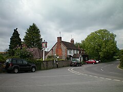
 The George pub | |
Location within West Sussex | |
| Area | 8.36 km2 (3.23 sq mi) [1] |
| Population | 111. 2011 Census[2] |
| • Density | 12/km2 (31/sq mi) |
| OS grid reference | SU939094 |
| • London | 49 miles (79 km) NNE |
| Civil parish |
|
| District | |
| Shire county | |
| Region | |
| Country | England |
| Sovereign state | United Kingdom |
| Post town | CHICHESTER |
| Postcode district | PO18 |
| Dialling code | 01243 |
| Police | Sussex |
| Fire | West Sussex |
| Ambulance | South East Coast |
| UK Parliament | |
Eartham is a village and civil parish in the District of Chichester in West Sussex, England located 8.5 kilometres (5.3 mi) northeast of Chichester east of the A285 road.
There is an Anglican parish church dedicated to St Margaret and a public house, The George, formerly The George and Dragon. The adjoining Manor Farm is the centre of a large farming enterprise. Nearby is Eartham House designed by Sir Edwin Lutyens which has been used since the 1920s as a private preparatory (junior) school, Great Ballard School. Eartham Wood to the north is an area of open access woodland, mostly beech trees through which the Roman road Stane Street runs. The route here today is followed only by bridleways and footpaths, and within Eartham Wood is part of the Monarch's Way long-distance path.
The parish has a land area of 836 hectares (2066 acres). In the 2001 census 104 people lived in 42 households, of whom 48 were economically active. At the 2011 Census the population including the hamlet of Upwaltham was 111.[2]
- ^ "2001 Census: West Sussex – Population by Parish" (PDF). West Sussex County Council. Archived from the original (PDF) on 8 June 2011. Retrieved 12 April 2009.
- ^ a b "Civil Parish population 2011". Neighbourhood Statistics. Office for National Statistics. Retrieved 14 October 2015.
