Back إيست باتشوغ Arabic ايست باتشوج ARZ ایست پاچآق نیویورک AZB East Patchogue Catalan East Patchogue CEB East Patchogue Spanish East Patchogue (New York) Basque ایست پاچآگ نیویورک Persian East Patchogue French East Patchogue Italian
This article needs additional citations for verification. (May 2009) |
East Patchogue, New York | |
|---|---|
 A park in East Patchogue. | |
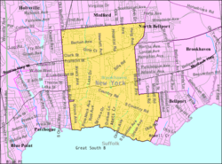
 U.S. Census map of East Patchogue. | |
| Coordinates: 40°46′6″N 72°58′59″W / 40.76833°N 72.98306°W | |
| Country | |
| State | |
| County | Suffolk |
| Town | Brookhaven |
| Named for | Its location immediately east of Patchogue |
| Area | |
| • Total | 8.46 sq mi (21.92 km2) |
| • Land | 8.32 sq mi (21.54 km2) |
| • Water | 0.14 sq mi (0.37 km2) |
| Elevation | 23 ft (7 m) |
| Population (2020) | |
| • Total | 21,580 |
| • Density | 2,594.37/sq mi (1,001.66/km2) |
| Time zone | UTC−05:00 (Eastern Time Zone) |
| • Summer (DST) | UTC−04:00 |
| ZIP Code | 11772 |
| Area code(s) | 631, 934 |
| FIPS code | 36-22733 |
| GNIS feature ID | 0949199 |
East Patchogue (/ˈpætʃɒɡ/, PATCH-awg) is a census-designated place (CDP) in the Town of Brookhaven in Suffolk County, on the South Shore of Long Island, in New York, United States. The population was 22,469 at the 2010 census.[2] The CDP is a proximate representation of the East Patchogue hamlet used for statistical purposes of the Census Bureau.
- ^ "ArcGIS REST Services Directory". United States Census Bureau. Retrieved September 20, 2022.
- ^ "U.S. Census website". United States Census Bureau. Retrieved January 31, 2008.
