Back ایستلیکس، نیو ساوت ولز Persian איסטלייקס HE Eastlakes Polish Eastlakes, New South Wales Romanian ایسٹ لیکس، نیو ساؤتھ ویلز Urdu
| Eastlakes Sydney, New South Wales | |||||||||||||||
|---|---|---|---|---|---|---|---|---|---|---|---|---|---|---|---|
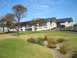
 Clubhouse, The Lakes Golf Club | |||||||||||||||
 | |||||||||||||||
| Population | 6,347 (2021 census)[1] | ||||||||||||||
| • Density | 7,900/km2 (20,500/sq mi) | ||||||||||||||
| Postcode(s) | 2018 | ||||||||||||||
| Elevation | 20 m (66 ft) | ||||||||||||||
| Area | 0.8 km2 (0.3 sq mi) | ||||||||||||||
| Location | 8 km (5 mi) south of Sydney CBD | ||||||||||||||
| LGA(s) | Bayside Council | ||||||||||||||
| State electorate(s) | |||||||||||||||
| Federal division(s) | Kingsford Smith | ||||||||||||||
| |||||||||||||||
Eastlakes is an inner southern and eastern suburb of Sydney, in the state of New South Wales, Australia. Eastlakes is located 8 kilometres south of the Sydney central business district, in the local government area of the Bayside Council, Eastlakes is mostly residential with a shopping centre located at Evans Avenue. The residential portion of the suburb falls in the inner south being west of the Eastern Distributor while the non-residential side of the suburb consisting of The Lakes Golf Course and Botany Dams is east of the Eastern Distributor falling within the Eastern Suburbs, south-east of the CBD.
There is a new shopping centre which opened in 2021 built across the road from the current shopping centre. Now that the new one is complete the current one will be redeveloped in the future. Golf courses also take up part of the suburb.
- ^ Australian Bureau of Statistics (28 June 2022). "Eastlakes (State Suburb)". 2021 Census QuickStats. Retrieved 13 August 2024.
 Material was copied from this source, which is available under a Creative Commons Attribution 4.0 International License.