Back اقرمونت، کامبریا AZB Egremont (lungsod) CEB Egremont, Cumbria Welsh Egremont Spanish Egremont (Cumbria) Basque اگرمونت، کامبریا Persian Egremont (Cumbria) French Egremont, Cumbria Irish Egremont (Cumbria) Italian Egremont LLD
| Egremont | |
|---|---|
| Town and parish | |
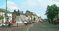
 Main Street, Egremont | |
Location within Cumbria | |
| Population | 8,194 (2011)[1] |
| OS grid reference | NY008109 |
| Civil parish |
|
| Unitary authority | |
| Ceremonial county | |
| Region | |
| Country | England |
| Sovereign state | United Kingdom |
| Post town | EGREMONT |
| Postcode district | CA22 |
| Dialling code | 01946 |
| Police | Cumbria |
| Fire | Cumbria |
| Ambulance | North West |
| UK Parliament | |
Egremont /ˈɛɡrəmənt/ is a market town, civil parish and two electoral wards in Cumbria, England, and historically part of Cumberland. It is situated just outside the Lake District National Park, five miles (eight kilometres) south of Whitehaven and on the River Ehen.
The town, which lies at the foot of Uldale Valley and Dent Fell, has a long industrial heritage including dyeing, weaving and iron ore mining. It had a population of 7,444 in 2001,[2] increasing to 8,194 at the 2011 Census.[1]
The town's layout today is much the same as at the time of Richard de Lucy around 1200 with its wide Main Street opening out into the market place. The remains of the Norman castle, built in the 12th century, are situated at the southern end of Main Street near the market place.
Egremont was granted a charter for a market and annual fair by King Henry III in 1266.[3] The resulting annual Crab Fair now hosts the World Gurning Championships.[4]
The modern economy is based around the nuclear industry at Sellafield.
- ^ a b UK Census (2011). "Local Area Report – Egremont Parish (E04012138)". Nomis. Office for National Statistics. Retrieved 22 April 2021.
- ^ UK Census (2001). "Local Area Report – Egremont Parish (16UE006)". Nomis. Office for National Statistics. Retrieved 22 April 2021.
- ^ "Parishes: Edenhall - Grinsdale | British History Online". www.british-history.ac.uk.
- ^ "Egremont gurning at Crab Fayre - World Gurning Competition Choosing the ugliest face part of Whitehaven.org.uk Cumbria". www.whitehaven.org.uk.

