| El Dorado Fire | |
|---|---|
 El Dorado Fire on September 5, 2020 | |
| Date(s) |
|
| Location |
|
| Coordinates | 34°03′29″N 116°59′22″W / 34.05806°N 116.98944°W |
| Statistics | |
| Burned area | 22,744 acres (9,204 ha; 35.538 sq mi) |
| Impacts | |
| Deaths | 1 firefighter |
| Non-fatal injuries | 12 |
| Structures destroyed | 10 structures destroyed, 6 structures damaged |
| Damage | ≥$42 million[1] |
| Ignition | |
| Cause | Sparked by a pyrotechnic device at a gender reveal party |
| Map | |
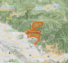
 The fire largely burned in the San Bernardino National Forest south of Big Bear Lake and north of Oak Glen | |
The El Dorado Fire was a wildfire that burned 22,744 acres (9,204 ha; 35.538 sq mi; 92.04 km2) in San Bernardino and Riverside counties of California from September to November 2020. It was ignited on September 5 by a pyrotechnic device at a gender reveal party in El Dorado Ranch Park; it quickly spread to the San Gorgonio Wilderness Area of the San Bernardino National Forest. Burning over a 71-day period, the fire destroyed 20 structures and resulted in one firefighter fatality, for which the couple hosting the party were charged with involuntary manslaughter.

