Back إل باسو (إلينوي) Arabic ايل پاسو (ايلينوى) ARZ الپاسو، ایلینوی AZB El Paso (Illinois) Catalan Эль-Пасо (Иллинойс) CE El Paso (lungsod sa Tinipong Bansa, Illinois) CEB El Paso, Illinois Welsh El Paso (Illinois) German El Paso (Illinois) Spanish El Paso (Illinois) Basque
El Paso, Illinois | |
|---|---|
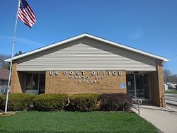
 El Paso Post Office | |
 Location in Woodford County, Illinois | |
| Coordinates: 40°44′26″N 89°01′06″W / 40.74056°N 89.01833°W | |
| Country | United States |
| State | Illinois |
| Counties | Woodford, McLean |
| Townships | El Paso, Gridley |
| Government | |
| • Mayor | JW Price |
| Area | |
| • Total | 2.15 sq mi (5.56 km2) |
| • Land | 2.15 sq mi (5.56 km2) |
| • Water | 0.00 sq mi (0.00 km2) |
| Elevation | 748 ft (228 m) |
| Population | |
| • Total | 2,756 |
| • Density | 1,284.85/sq mi (496.04/km2) |
| Time zone | UTC-6 (CST) |
| • Summer (DST) | UTC-5 (CDT) |
| ZIP code | 61738 |
| Area code | 309 |
| FIPS code | 17-23737 |
| FIPS code | 17-23737 |
| GNIS ID | 2394632[2] |
| Wikimedia Commons | El Paso, Illinois |
| Website | www |
El Paso is a city in Woodford and McLean counties in the U.S. state of Illinois. The population was 2,756 at the 2020 census.[3] The Woodford County portion of El Paso is part of the Peoria Metropolitan Statistical Area.
El Paso is a small community in central Illinois that took on more characteristics of a highway community after the construction of Interstate 39, which supplanted the older alignment of U.S. Highway 51.[citation needed]
- ^ "2022 U.S. Gazetteer Files: Illinois". United States Census Bureau. Retrieved March 7, 2023.
- ^ a b U.S. Geological Survey Geographic Names Information System: El Paso, Illinois
- ^ a b "P1. Race – El Paso city, Illinois: 2020 DEC Redistricting Data (PL 94-171)". U.S. Census Bureau. Retrieved March 7, 2023.
