| Burnett Queensland—Legislative Assembly | |||||||||||||||
|---|---|---|---|---|---|---|---|---|---|---|---|---|---|---|---|
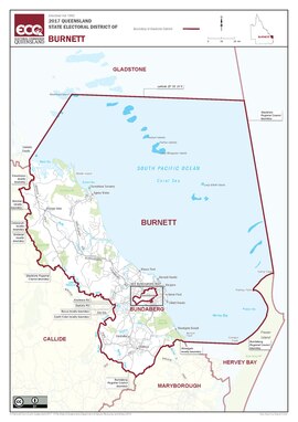 Map of the electoral district of Burnett, 2017 | |||||||||||||||
| State | Queensland | ||||||||||||||
| MP | Stephen Bennett | ||||||||||||||
| Party | Liberal National | ||||||||||||||
| Namesake | Burnett River | ||||||||||||||
| Electors | 35,928 (2020) | ||||||||||||||
| Area | 7,687 km2 (2,968.0 sq mi) | ||||||||||||||
| Demographic | Rural | ||||||||||||||
| Coordinates | 24°37′S 152°2′E / 24.617°S 152.033°E | ||||||||||||||
| |||||||||||||||

Burnett is an electoral division of the Legislative Assembly of Queensland in central Queensland, Australia.[1]
It covers most of the coastal region south of Gladstone, as well as coastal and inland regions completely surrounding the district of Bundaberg. Towns within its boundaries include Miriam Vale, Agnes Water, Rosedale, Bargara, Woodgate and Childers. The Burnett River flows through the electoral district, hence its name.
- ^ "Representatives of Queensland State Electorates 1860-2017" (PDF). Queensland Parliamentary Record 2012-2017: The 55th Parliament. Queensland Parliament. Archived from the original (PDF) on 27 April 2020. Retrieved 27 April 2020.