| Geelong East Victoria—Legislative Assembly | |
|---|---|
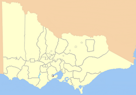
 Location in Victoria, 1859 | |
| State | Victoria |
| Dates current | 1859–1877, 1976–1985 |
| Demographic | Urban |
Geelong East was an electoral district of the Legislative Assembly[1] in the Australian state of Victoria from 1859 to 1985. It was located south of the city of Geelong, defined in the Victorian Electoral Act, 1858 as:
Commencing at the north-western angle of the town reserve of Geelong; thence by a line south to the River Barwon; thence westward and northwestward by the River Barwon to the western boundary of the reserve at the junction of the Moorabool and Barwon; thence east by the northern boundary of section 25, parish of Barrabool; thence south by the eastern boundaries of sections 25 and 11, and by part of the eastern boundary of section 7, all in the same parish; thence south-easterly by a curved line crossing the Waurn Chain of Ponds to the southern boundary of section 3, parish of Conewarre; thence east by the southern boundaries of sections 3 and 4 in the same parish; thence north-easterly by a curved line crossing the River Barwon to the south-eastern angle of section 11 in the parish of Moolap; thence by the eastern boundary of that section and a line north to the shores of Corio Bay; and thence by the shores of Corio Bay to the north-western angle of the town reserve, the commencing point aforesaid, including the remaining portion of the reserve at Point Henry.[2]
Geelong East (along with Electoral district of Geelong West) was created when the four-member Electoral district of Geelong was abolished in 1859. Geelong West and Geelong East were abolished in 1877, replaced by a re-created 3-member district of Geelong.[1]
After the Electoral district of Bellarine was abolished in 1976, Geelong East was re-created. In 1985, population increases caused another redrawing of electoral boundaries; Geelong East was abolished and Bellarine re-created that year. Graham Ernst, last member for Geelong East, represented Bellarine 1985–1992.[3]
- ^ a b "Former Members". re-member: a database of all Victorian MPs since 1851. Parliament of Victoria. Retrieved 25 August 2022.
- ^ "An Act to alter the Electoral Districts of Victoria and to increase the number of Members of the Legislative Assembly thereof" (PDF). 1858. Retrieved 24 April 2013.
- ^ "Graham Keith Ernst". Re-Member: a database of all Victorian MPs since 1851. Parliament of Victoria. Archived from the original on 23 April 2023. Retrieved 24 April 2013.
