| Toowoomba South Queensland—Legislative Assembly | |||||||||||||||
|---|---|---|---|---|---|---|---|---|---|---|---|---|---|---|---|
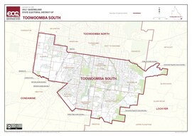 Electoral map of Toowoomba South 2017 | |||||||||||||||
| State | Queensland | ||||||||||||||
| MP | David Janetzki | ||||||||||||||
| Party | Liberal National Party | ||||||||||||||
| Namesake | Toowoomba | ||||||||||||||
| Electors | 37,750 (2020) | ||||||||||||||
| Area | 44 km2 (17.0 sq mi) | ||||||||||||||
| Demographic | Provincial | ||||||||||||||
| Coordinates | 27°35′S 151°57′E / 27.583°S 151.950°E | ||||||||||||||
| |||||||||||||||

Toowoomba South is an electoral district of the Legislative Assembly in the Australian state of Queensland. It was created with the 1972 redistribution, and replaced the abolished Toowoomba East.[1]
The electorate covers the eastern and inner southern suburbs of Toowoomba. It excludes the outer southern suburbs of Toowoomba, Drayton, Darling Heights and the other areas near the University of Southern Queensland, which fall in Condamine.
It is part of the Darling Downs group of seats, and is bounded on the east by Lockyer, the north by Toowoomba North, and on the south and west by Condamine.
The electorate was held by John McVeigh for the Liberal National Party, until his resignation on 29 April 2016 to contest the federal seat of Groom at the 2016 federal election. David Janetzki was elected at the subsequent by-election on 16 July 2016.[2]
- ^ "Representatives of Queensland State Electorates 1860-2017" (PDF). Queensland Parliamentary Record 2012-2017: The 55th Parliament. Queensland Parliament. Archived from the original (PDF) on 27 April 2020.
- ^ "Toowoomba South by-election to be held in July". ABC News. Sydney. 10 May 2016. Retrieved 2 June 2016.