Back إلغن (أريزونا) Arabic القین (آریزونا) AZB Elgin (Arizona) Catalan Елджин (Аризона) CE Elgin (lungsod sa Tinipong Bansa, Arizona) CEB Elgin (Arizona) German Elgin (Arizona) Spanish Elgin (Arizona) Basque الگین (آریزونا) Persian Elgin (Arizona) French
Elgin, Arizona | |
|---|---|
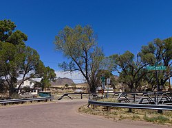
 View across Babocomari Creek toward the site of the railroad depot. | |
 Location in Santa Cruz County and the state of Arizona | |
| Coordinates: 31°37′45″N 110°34′19″W / 31.62917°N 110.57194°W | |
| Country | United States |
| State | Arizona |
| County | Santa Cruz |
| Area | |
| • Total | 5.95 sq mi (15.41 km2) |
| • Land | 5.95 sq mi (15.40 km2) |
| • Water | 0.00 sq mi (0.00 km2) |
| Elevation | 4,728 ft (1,441 m) |
| Population (2020) | |
| • Total | 162 |
| • Density | 27.24/sq mi (10.52/km2) |
| Time zone | UTC-7 (MST (no DST)) |
| ZIP code | 85611 |
| Area code | 520 |
| FIPS code | 04-22150 |
| GNIS feature ID | 28852[2] |
Elgin is a census-designated place (CDP) in Santa Cruz County, Arizona, United States. The population was 161 at the 2010 census.[3]
- ^ "2020 U.S. Gazetteer Files". United States Census Bureau. Retrieved October 29, 2021.
- ^ a b U.S. Geological Survey Geographic Names Information System: Elgin, Arizona
- ^ "Geographic Identifiers: 2010 Demographic Profile Data (G001): Elgin CDP, Arizona". U.S. Census Bureau, American Factfinder. Archived from the original on February 12, 2020. Retrieved December 4, 2012.

