Back Elig ANG إيلي (كامبريدجشير) Arabic ايلى (مدينه) ARZ الی، کمبریجشایر AZB Ілі (Англія) Byelorussian Или Bulgarian Ely (ciutat d'Anglaterra) Catalan Ely (lungsod sa Hiniusang Gingharian, Inglatera, Cambridgeshire, lat 52,40, long 0,26) CEB Ely Czech Ely Welsh
| Ely | |
|---|---|
| Cathedral city | |
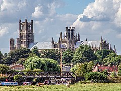
 Ely Cathedral from the south-east | |
Location within Cambridgeshire | |
| Area | 69 sq mi (180 km2) [1] |
| Population | 19,200 (2021 census) |
| • Density | 278/sq mi (107/km2) |
| Civil parish |
|
| District | |
| Shire county | |
| Region | |
| Country | England |
| Sovereign state | United Kingdom |
| Post town | ELY |
| Postcode district | CB6, CB7 |
| Dialling code | 01353 |
| Police | Cambridgeshire |
| Fire | Cambridgeshire |
| Ambulance | East of England |
| UK Parliament | |
| Website | visitely |
Ely (/ˈiːli/ EE-lee) is a cathedral city in Cambridgeshire, England, 14 miles (23 km) northeast of Cambridge, 24 miles (39 km) southeast of Peterborough and 80 miles (130 km) from London. At the 2021 census, it had a population of 19,200.[2]
Ely is built on a 23-square-mile (60 km2) Kimmeridge Clay island which, at 85 feet (26 m), is the highest land in the Fens. It was due to this topography that Ely was not waterlogged like the surrounding Fenland, and an island separated from the mainland.[3] Major rivers including the Witham, Welland, Nene and Great Ouse feed into the Fens and, until draining commenced in the eighteenth century, formed freshwater marshes and meres within which peat was laid down. Once the Fens were drained, this peat created a rich and fertile soil ideal for farming.
The River Great Ouse was a significant means of transport until the Fens were drained and Ely ceased to be an island in the seventeenth century.[4] The river is now a popular boating spot and has a large marina. Although now surrounded by land, the city is still known as the Isle of Ely.
There are two Sites of Special Scientific Interest in the city: a former Kimmeridge Clay quarry, and one of the United Kingdom's best remaining examples of medieval ridge and furrow agriculture.
The economy of the region is mainly agricultural. Before the Fens were drained, eel fishing was an important activity, from which the settlement's name may have been derived. Other important activities included wildfowling, peat extraction, and the harvesting of osier (willow) and sedge (rush). The city had been the centre of local pottery production for more than 700 years, including pottery known as Babylon ware. A Roman road, Akeman Street, passes through the city; the southern end is at Ermine Street near Wimpole and its northern end is at Brancaster. Little direct evidence of Roman occupation in Ely exists, although there are nearby Roman settlements such as those at Little Thetford and Stretham.
A coach route, known to have existed in 1753 between Ely and Cambridge, was improved in 1769 as a turnpike (toll road). The present-day A10 closely follows this route. Ely railway station, built in 1845, is on the Fen Line and is now a railway hub, with lines north to King's Lynn, northwest to Peterborough, east to Norwich, southeast to Ipswich and south to Cambridge and London.
Henry II granted the first annual fair, Saint Etheldreda's (or Saint Audrey's) seven-day event, to the abbot and convent on 10 October 1189. The word "tawdry" originates from cheap lace sold at this fair. A weekly market has taken place in Ely Market Square since at least the 13th century. Markets are now held on Thursdays, Saturdays and Sundays, with a farmers' market on the second and fourth Saturdays of each month.
Present-day annual events include the Eel Festival in May, established in 2004, and a fireworks display in Ely Park, first staged in 1974. The city of Ely has been twinned with Denmark's oldest town, Ribe, since 1956. Ely City Football Club was formed in 1885.
- ^ Cite error: The named reference
CambsCensuswas invoked but never defined (see the help page). - ^ "Build a custom area profile - Census 2021, ONS". www.ons.gov.uk. Retrieved 22 March 2024.
- ^ "The History of Ely, Cambridgeshire".
- ^ Darby 1974, pp. 93–106
