Back Еордея (македонска област) Bulgarian Eòrdia Catalan Eordaia German Εορδαία Greek Eordia Spanish Eordaia Finnish Eordia Italian Еордеја Macedonian Eordaja Polish Eordea Albanian
This article needs additional citations for verification. (September 2011) |

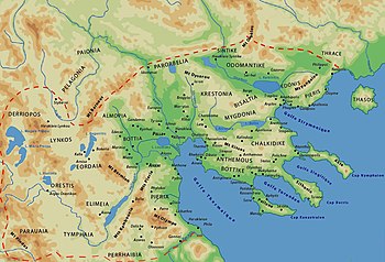
Eordaea (also spelled Eordaia or Eordia, Greek: Ἐορδαία) was a geographical region of upper Macedonia and later an administrative region of the kingdom of Macedon. Eordaea was located south of Lynkestis, west of Emathia, north of Elimiotis and east of Orestis.[1]
Eordaea stretched in the basin of Eordaia, the current homonymous municipality in Greece, which is named after the ancient region, and also in the southern part of the municipality of Amyntaio and the western part of the municipality of Edessa.
The capital of Eordaea was the city of Eordaea (el) (Greek: Εορδαία, κείμενη της λίμνης), which was mentioned by many historians and geographers of antiquity.
- ^ Dimitrios C. Samsaris, Historical Geography of the Roman province of Macedonia (The Departmement of Western Macedonia today) (in Greek), Thessaloniki 1989