Farbill
Fir Bhile | |
|---|---|
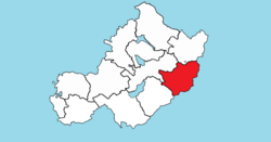
 Location of Farbill on a map of Westmeath | |
| Coordinates: 53°30′09″N 7°08′27″W / 53.5025°N 7.1408°W | |
| Country | Ireland |
| Province | Leinster |
| County | Westmeath |
| Area | |
| • Total | 143.6 km2 (55.4 sq mi) |
| Time zone | UTC+0 (WET) |
| • Summer (DST) | UTC+1 (IST (WEST)) |
| Irish Grid Reference | N570505 |
Farbill (Irish: Fir Bhile)[1] is a barony in east County Westmeath, in Ireland. It was formed by 1672.[2] It is bordered by County Meath to the south and east and three other baronies: Fartullagh (to the south–west), Moyashel and Magheradernon (to the north–east) and Delvin (to the north). The largest centre of population in the barony is the town of Kinnegad.
- ^ "Fir Bhile / Farbill". logainm.ie - The Placenames Database of Ireland. Retrieved 4 March 2021.
- ^ Barony of Farbill townlands.ie Retrieved 30 May 2015

