| Felsenthal National Wildlife Refuge | |
|---|---|
IUCN category IV (habitat/species management area) | |
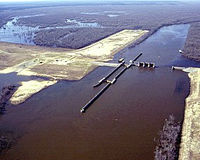
 Felsenthal Lock and Dam, impounding the Felsenthal basin (historically called Lake Jack Lee) | |
Map of the United States | |
| Location | Arkansas, United States |
| Nearest city | Crossett, Arkansas |
| Coordinates | 33°05′25″N 92°08′31″W / 33.090409°N 92.141819°W |
| Area | 76,000 acres (310 km2) |
| Elevation | 65 feet is the normal navigation pool elevation above the mean sea level[1] |
| Established | 1975 |
| Governing body | U.S. Fish and Wildlife Service |
| Website | Felsenthal NWR |
The Felsenthal National Wildlife Refuge (NWR) is a 76,000 acre (307.56 km2) national wildlife refuge located in south-central Arkansas in Ashley, Bradley, and Union counties. Felsenthal NWR is one of three refuges forming an administrative complex, which also includes Pond Creek NWR to the northwest and Overflow NWR to the east.[2]
- ^ Ouachita and Black Rivers Nine-foot Navigation Project (AR,LA) | U.S. Army Engineer District, Vicksburg, Mississippi | 1974
- ^ "About Us: Other Facilities in this Complex". Felsenthal National Wildlife Refuge. U.S. Fish and Wildlife Service. Retrieved 3 June 2022.

