  | |||||||||
|---|---|---|---|---|---|---|---|---|---|
| Peel Regional Road 2 Durham Regional Road 37 | |||||||||
 | |||||||||
| Maintained by | City of Toronto Region of Peel Region of Durham | ||||||||
| Length | 52 km (32 mi) | ||||||||
| Location | Toronto Mississauga Brampton Pickering | ||||||||
| West end | (in Brampton) | ||||||||
| Major junctions | Martin Grove Road Albion Road Kipling Avenue Islington Avenue Weston Road Jane Street Keele Street Dufferin Street Bathurst Street Yonge Street Bayview Avenue Leslie Street Don Mills Road Victoria Park Avenue Warden Avenue Kennedy Road McCowan Road Markham Road Neilson Road Morningside Avenue ---Road branches--- Sewells Road (Shifts up North via Sewells Road) Ressor Road Meadowvale Road | ||||||||
| East end | (in Pickering) | ||||||||
| |||||||||
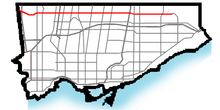
Finch Avenue is an arterial thoroughfare that travels east–west in Toronto, Ontario, Canada. The road continues west into the Regional Municipality of Peel as Regional Road 2 and east into the Regional Municipality of Durham as Regional Road 37.
The road is considered a high-density transit corridor by Metrolinx. At its intersection with Yonge Street in North York, the Finch subway station and Finch Bus Terminal carry some of the highest numbers of commuters in the city.
