Back فیشرآیلند، نیویورک AZB Fishers Island Catalan Фишерс-Айленд (Нью-Йорк) CE Fishers Island (lungsod) CEB Fishers Island (New York) German Fishers Island Spanish Fishers Island (New York) Basque فیشرآیلند، نیویورک Persian Fishers Island (New York) French Fishers Island Italian
This article needs additional citations for verification. (February 2011) |
Fishers Island, New York
Munnawtawkit | |
|---|---|
 Fishers Island with the coast of Groton, Connecticut in the background. | |
 | |
 | |
| Coordinates: 41°15′43″N 72°0′26″W / 41.26194°N 72.00722°W | |
| Country | United States |
| State | New York |
| County | Suffolk |
| Town | Southold |
| Area | |
| • Total | 4.97 sq mi (12.86 km2) |
| • Land | 4.06 sq mi (10.50 km2) |
| • Water | 0.91 sq mi (2.36 km2) |
| Elevation | 16 ft (5 m) |
| Population (2020) | |
| • Total | 424 |
| • Density | 104.54/sq mi (40.36/km2) |
| Time zone | UTC−5 (Eastern (EST)) |
| • Summer (DST) | UTC−4 (EDT) |
| ZIP Code | 06390 (originally 11943) |
| Area code | 631 |
| FIPS code | 36-25923 |
| GNIS feature ID | 950166 (populated place) 950165 (island) |
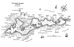
Fishers Island (Pequot: Munnawtawkit) is an island that is part of Southold, New York, United States at the eastern end of Long Island Sound, 2 miles (3 km) off the southeastern coast of Connecticut across Fishers Island Sound. About 9 miles (14 km) long and 1 mile (1.6 km) wide, it is about 11 miles (18 km) from the tip of Long Island at Orient Point, 2 miles (3 km) each from Napatree Point at the southwestern tip of Rhode Island and Groton Long Point in Connecticut, and about 7 miles (11 km) southeast of New London, Connecticut. It is accessible from New London by plane and regular ferry service.
The island is part of the town of Southold in Suffolk County. It is a census-designated place (CDP). As of the 2010 census, there were 236 people living year-round on 4.1 square miles (10.6 km2) of land.[2] The population rises to about 2,000 during peak summer weekends, as throngs disembark on the island from Connecticut.
- ^ "ArcGIS REST Services Directory". United States Census Bureau. Retrieved September 20, 2022.
- ^ "Geographic Identifiers: 2010 Demographic Profile Data (G001): Fishers Island CDP, New York". U.S. Census Bureau, American Factfinder. Archived from the original on February 12, 2020. Retrieved December 28, 2012.