Back جزيرة فلوريانا Arabic Islla Floreana (Islles Galápagos) AST Floreana Catalan Floreana Island CEB Floreana Czech Floreana German Isla Floreana Spanish Floreana Estonian ساحل فلوریانا Persian Floreana Finnish
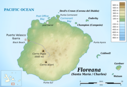
 Topographic map of Floreana | |
| Geography | |
|---|---|
| Location | East Pacific Ocean |
| Coordinates | 1°17′51″S 90°26′03″W / 1.29750°S 90.43417°W |
| Archipelago | Galápagos Islands |
| Area | 173 km2 (67 sq mi) |
| Highest elevation | 640 m (2100 ft) |
| Highest point | Cerro Pajas |
| Administration | |
Ecuador | |
| Province | Galápagos Province |
| Canton | San Cristóbal |
| Parish | Santa María |
| Capital and largest city | Puerto Velasco Ibarra (pop. 100) |
| Demographics | |
| Population | 100 |
| Pop. density | 0.6/km2 (1.6/sq mi) |
Floreana Island (Spanish: Isla Floreana) is a southern island in Ecuador's Galápagos Archipelago. The island has an area of 173 km2 (67 sq mi). It was formed by volcanic eruption. The island's highest point is Cerro Pajas at 640 m (2,100 ft), which is also the highest point of the volcano like most of the smaller islands of Galápagos. The island has a population of about 100.
