| Floyd River | |
|---|---|
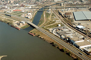
 Confluence of the Missouri and Floyd Rivers in Sioux City | |
 Floyd River watershed (Interactive map) | |
| Location | |
| Country | United States |
| State | Iowa |
| District | Woodbury County, Iowa, Plymouth County, Iowa, Sioux County, Iowa, O'Brien County, Iowa |
| Physical characteristics | |
| Source | |
| • location | O'Brien County, near Silver Ave and 290th St. |
| • coordinates | 43°14′31″N 95°37′16″W / 43.242°N 95.621°W |
| Mouth | Missouri River |
• coordinates | 42°28′59″N 96°23′31″W / 42.483°N 96.392°W |
• elevation | 1,079 ft (329 m) |
| Basin size | 2,400 km2 (930 sq mi) |
| Discharge | |
| • location | mouth |
| • average | 340 cu ft/s (9.6 m3/s) (estimate)[1] |
The Floyd River is a tributary of the Missouri River, 112 miles (180 km) long,[2] in northwestern Iowa in the United States. It enters the Missouri at Sioux City, and is named for Charles Floyd,[3] a member of the Lewis and Clark Expedition.
- ^ United States Environmental Protection Agency. "Watershed Report: Floyd River". WATERS GeoViewer. Archived from the original on July 17, 2021. Retrieved July 17, 2021.
- ^ U.S. Geological Survey. National Hydrography Dataset high-resolution flowline data. The National Map Archived 2012-03-29 at the Wayback Machine, accessed March 30, 2011
- ^ Gannett, Henry (1905). The Origin of Certain Place Names in the United States. Govt. Print. Off. pp. 127.
