Back Fordham Road (línea de la Avenida Jerome) Spanish Fordham Road (linea IRT Jerome Avenue) Italian フォーダム・ロード駅 (IRTジェローム・アベニュー線) Japanese Fordham Road (Jerome Avenue Line) Dutch Fordham Road (stacja metra na Jerome Avenue Line) Polish Фордем-роуд (линия Джером-авеню, Ай-ар-ти) Russian 福德漢姆路車站 (IRT傑羅姆大道線) Chinese
Fordham Road | ||||||||||||||||||||||||||||||||||||||||||||||||||||||||||||||||||||
|---|---|---|---|---|---|---|---|---|---|---|---|---|---|---|---|---|---|---|---|---|---|---|---|---|---|---|---|---|---|---|---|---|---|---|---|---|---|---|---|---|---|---|---|---|---|---|---|---|---|---|---|---|---|---|---|---|---|---|---|---|---|---|---|---|---|---|---|---|
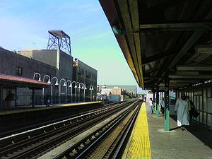
 Platform view | ||||||||||||||||||||||||||||||||||||||||||||||||||||||||||||||||||||
| Station statistics | ||||||||||||||||||||||||||||||||||||||||||||||||||||||||||||||||||||
| Address | Fordham Road & Jerome Avenue Bronx, NY | |||||||||||||||||||||||||||||||||||||||||||||||||||||||||||||||||||
| Borough | The Bronx | |||||||||||||||||||||||||||||||||||||||||||||||||||||||||||||||||||
| Locale | University Heights, Fordham | |||||||||||||||||||||||||||||||||||||||||||||||||||||||||||||||||||
| Coordinates | 40°51′46″N 73°54′04″W / 40.862706°N 73.901124°W | |||||||||||||||||||||||||||||||||||||||||||||||||||||||||||||||||||
| Division | A (IRT)[1] | |||||||||||||||||||||||||||||||||||||||||||||||||||||||||||||||||||
| Line | IRT Jerome Avenue Line | |||||||||||||||||||||||||||||||||||||||||||||||||||||||||||||||||||
| Services | 4 | |||||||||||||||||||||||||||||||||||||||||||||||||||||||||||||||||||
| Transit | ||||||||||||||||||||||||||||||||||||||||||||||||||||||||||||||||||||
| Structure | Elevated | |||||||||||||||||||||||||||||||||||||||||||||||||||||||||||||||||||
| Platforms | 2 side platforms | |||||||||||||||||||||||||||||||||||||||||||||||||||||||||||||||||||
| Tracks | 3 (2 in regular service) | |||||||||||||||||||||||||||||||||||||||||||||||||||||||||||||||||||
| Other information | ||||||||||||||||||||||||||||||||||||||||||||||||||||||||||||||||||||
| Opened | June 2, 1917 | |||||||||||||||||||||||||||||||||||||||||||||||||||||||||||||||||||
| Accessible | ||||||||||||||||||||||||||||||||||||||||||||||||||||||||||||||||||||
| Opposite- direction transfer | Yes | |||||||||||||||||||||||||||||||||||||||||||||||||||||||||||||||||||
| Traffic | ||||||||||||||||||||||||||||||||||||||||||||||||||||||||||||||||||||
| 2023 | 2,269,772[3] | |||||||||||||||||||||||||||||||||||||||||||||||||||||||||||||||||||
| Rank | 146 out of 423[3] | |||||||||||||||||||||||||||||||||||||||||||||||||||||||||||||||||||
| ||||||||||||||||||||||||||||||||||||||||||||||||||||||||||||||||||||
| ||||||||||||||||||||||||||||||||||||||||||||||||||||||||||||||||||||
| ||||||||||||||||||||||||||||||||||||||||||||||||||||||||||||||||||||
| ||||||||||||||||||||||||||||||||||||||||||||||||||||||||||||||||||||
| ||||||||||||||||||||||||||||||||||||||||||||||||||||||||||||||||||||
The Fordham Road station is a local station on the IRT Jerome Avenue Line of the New York City Subway. Located at the intersection of Fordham Road and Jerome Avenue in the University Heights and Fordham Heights neighborhoods of the Bronx, it is served by the 4 train at all times. This station was constructed by the Interborough Rapid Transit Company as part of the Dual Contracts and opened in 1917.
- ^ "Glossary". Second Avenue Subway Supplemental Draft Environmental Impact Statement (SDEIS) (PDF). Vol. 1. Metropolitan Transportation Authority. March 4, 2003. pp. 1–2. Archived from the original (PDF) on February 26, 2021. Retrieved January 1, 2021.
- ^ "Bronx Bus Map" (PDF). Metropolitan Transportation Authority. October 2018. Retrieved December 1, 2020.
- ^ a b "Annual Subway Ridership (2018–2023)". Metropolitan Transportation Authority. 2023. Retrieved April 20, 2024.


