Back فورست (أوهايو) Arabic Forest (Ohio) Catalan Forest (lungsod sa Tinipong Bansa, Ohio) CEB Forest, Ohio Welsh Forest (Ohio) Spanish Forest (Ohio) Basque Forest (Ohio) French Forest, Ohio HT Forest (Ohio) Italian Forest (Ohio) LLD
Forest, Ohio | |
|---|---|
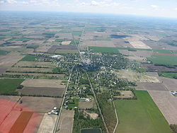
 Aerial view of Forest | |
 Location of Forest, Ohio | |
 Detailed map of Forest | |
| Coordinates: 40°48′18″N 83°30′42″W / 40.80500°N 83.51167°W | |
| Country | United States |
| State | Ohio |
| Counties | Hardin, Wyandot[1] |
| Area | |
| • Total | 1.44 sq mi (3.74 km2) |
| • Land | 1.44 sq mi (3.74 km2) |
| • Water | 0.00 sq mi (0.00 km2) |
| Elevation | 929 ft (283 m) |
| Population (2020) | |
| • Total | 1,350 |
| • Estimate (2023)[4] | 1,331 |
| • Density | 934.90/sq mi (360.97/km2) |
| Time zone | UTC-5 (Eastern (EST)) |
| • Summer (DST) | UTC-4 (EDT) |
| ZIP code | 45843 |
| Area code | 419 |
| FIPS code | 39-27636[5] |
| GNIS feature ID | 2398894[3] |
| Website | www |
Forest is a village in Hardin and Wyandot counties in the U.S. state of Ohio. The population was 1,350 at the 2020 census.
- ^ Hardin County, Ohio: Online Auditor - Map, Hardin County, January 25, 2011. Accessed 2011-01-25.
- ^ "ArcGIS REST Services Directory". United States Census Bureau. Retrieved September 20, 2022.
- ^ a b U.S. Geological Survey Geographic Names Information System: Forest, Ohio
- ^ "Annual Estimates of the Resident Population for Incorporated Places in Ohio: April 1, 2020 to July 1, 2023". United States Census Bureau. Retrieved June 25, 2024.
- ^ "U.S. Census website". United States Census Bureau. Retrieved January 31, 2008.