Back فور كولونج (كيبك) Arabic Fort-Coulonge (munisipyo) CEB Fort-Coulonge (Quebec) Basque فورت-کولونی، کبک Persian Fort-Coulonge French Fort-Coulonge, Quebec HAK Fort-Coulonge Italian Fort-Coulonge Portuguese Fort-Coulonge Swedish
Fort-Coulonge | |
|---|---|
 Rue Principale in Fort-Coulonge | |
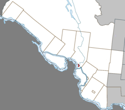
 Location within Pontiac RCM | |
| Coordinates: 45°51′N 76°44′W / 45.850°N 76.733°W[1] | |
| Country | Canada |
| Province | Quebec |
| Region | Outaouais |
| RCM | Pontiac |
| Constituted | December 15, 1888 |
| Government | |
| • Mayor | Christine Francoeur |
| • Federal riding | Pontiac |
| • Prov. riding | Pontiac |
| Area | |
| • Total | 3.17 km2 (1.22 sq mi) |
| • Land | 2.96 km2 (1.14 sq mi) |
| Population (2021)[3] | |
| • Total | 1,312 |
| • Density | 443.9/km2 (1,150/sq mi) |
| • Pop (2016-21) | |
| • Dwellings | 605 |
| Time zone | UTC−05:00 (EST) |
| • Summer (DST) | UTC−04:00 (EDT) |
| Postal code(s) | |
| Area code | 819 |
Fort Coulonge is a village in the Pontiac Regional County Municipality in western Quebec, Canada, at the mouth of the Coulonge River. It is the francophone centre of the otherwise largely (57%) anglophone Pontiac MRC, with 79.6% listing French as their mother tongue in the Canada 2006 Census.
Fort-Coulonge is known for the Félix-Gabriel-Marchand Bridge, Quebec's longest covered bridge which is actually in neighbouring Mansfield-et-Pontefract.
- ^ Cite error: The named reference
toponymiewas invoked but never defined (see the help page). - ^ a b "Répertoire des municipalités: Geographic code 84060". www.mamh.gouv.qc.ca (in French). Ministère des Affaires municipales et de l'Habitation.
- ^ a b "Fort-Coulonge, Village (VL) Census Profile, 2021 Census of Population". www12.statcan.gc.ca. Government of Canada - Statistics Canada. Retrieved 10 November 2022.
