Back فورت سالونغا (نيويورك) Arabic فورت سالونقا، نیویورک AZB Fort Salonga Catalan Форт-Салонга (Нью-Йорк) CE Fort Salonga CEB Fort Salonga (Nueva York) Spanish Fort Salonga (New York) Basque فورت سالونگا، نیویورک Persian Fort Salonga (New York) French Fort Salonga Italian
Fort Salonga, New York | |
|---|---|
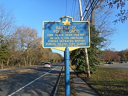
 Historic marker for the "Battle of Fort Slongo" along eastbound NY 25A. | |
 U.S. Census map of Fort Salonga | |
| Coordinates: 40°54′21″N 73°18′4″W / 40.90583°N 73.30111°W | |
| Country | |
| State | |
| County | Suffolk |
| Town | Huntington |
| Named for | Fort Salonga |
| Area | |
| • Total | 13.23 sq mi (34.26 km2) |
| • Land | 9.49 sq mi (24.58 km2) |
| • Water | 3.74 sq mi (9.68 km2) |
| Elevation | 33 ft (10 m) |
| Population (2020) | |
| • Total | 9,652 |
| • Density | 1,016.96/sq mi (392.67/km2) |
| Time zone | UTC-5 (Eastern (EST)) |
| • Summer (DST) | UTC-4 (EDT) |
| ZIP code | 11768 |
| Area code(s) | 631, 934 |
| FIPS code | 36-26946 |
| GNIS feature ID | 0950497 |
| Website | www |
Fort Salonga is a hamlet and census-designated place (CDP) in the Towns of Huntington and Smithtown in Suffolk County, on the North Shore of Long Island, in New York, United States. The population was 10,008 at the 2010 census.[2]
The hamlet is considered the easternmost part of the historic Gold Coast of Long Island, with the Geissler Estate being located within the hamlet.[3][4]
- ^ "ArcGIS REST Services Directory". United States Census Bureau. Retrieved September 20, 2022.
- ^ "Geographic Identifiers: 2010 Demographic Profile Data (G001): Fort Salonga CDP, New York". American Factfinder. U.S. Census Bureau. 2010. Archived from the original on February 12, 2020. Retrieved December 28, 2012.
- ^ "The History Of Fort Salonga". Fort Salonga. Retrieved July 22, 2022.
- ^ Michalos, Michelle. "A Guide to Long Island's Gold Coast Mansions". THIRTEEN - New York Public Media. Retrieved July 22, 2022.

