Back مقاطعة فرانكلين (واشنطن) Arabic Franklin County, Washington BAR Франклин (окръг, Вашингтон) Bulgarian ফ্রাঙ্কলিন কাউন্টি, ৱাশিংটন BPY Franklin Gông (Washington) CDO Франклин (гуо, Вашингтон) CE Franklin County (kondado sa Tinipong Bansa, Washington) CEB Franklin County (Washington) Czech Franklin County, Washington Welsh Franklin County (Washington) German
Franklin County | |
|---|---|
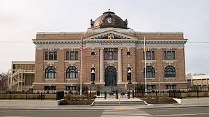
 Franklin County Courthouse in Pasco | |
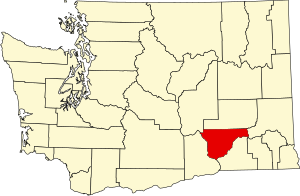
 Location within the U.S. state of Washington | |
 Washington's location within the U.S. | |
| Coordinates: 46°32′N 118°54′W / 46.54°N 118.9°W | |
| Country | |
| State | |
| Founded | November 28, 1883 |
| Named for | Benjamin Franklin |
| Seat | Pasco |
| Largest city | Pasco |
| Area | |
| • Total | 1,265 sq mi (3,280 km2) |
| • Land | 1,242 sq mi (3,220 km2) |
| • Water | 23 sq mi (60 km2) 1.8% |
| Population (2020) | |
| • Total | 96,749 |
| • Estimate (2023) | 99,034 |
| • Density | 76/sq mi (30/km2) |
| Time zone | UTC−8 (Pacific) |
| • Summer (DST) | UTC−7 (PDT) |
| Congressional districts | 4th, 5th |
| Website | www |
Franklin County is a county located in the U.S. state of Washington. As of the 2020 census, its population was 96,749.[1] The county seat and most populous city is Pasco.[2] The county was formed out of Whitman County on November 28, 1883,[3] and is named for Benjamin Franklin.[4]
Franklin County is included in the Tri-Cities metropolitan area. Together, Kennewick, Richland and Pasco comprise Washington's Tri-Cities.
- ^ "State & County QuickFacts". United States Census Bureau. Retrieved November 9, 2024.
- ^ "Find a County". National Association of Counties. Archived from the original on May 31, 2011. Retrieved June 7, 2011.
- ^ "Milestones for Washington State History — Part 2: 1851 to 1900". HistoryLink.org. March 6, 2003.
- ^ Gannett, Henry (1905). The Origin of Certain Place Names in the United States. Govt. Print. Off. pp. 131.