Back ФгӀене-суьгӀ-СагӀт CE Fresnay-sur-Sarthe German Fresnay-sur-Sarthe DIQ Fresnay-sur-Sarthe Esperanto Fresnay-sur-Sarthe French Fresnay-sur-Sarthe LLD Fresnay-sur-Sarthe Portuguese Френе-сюр-Сарт Tatar Френе-сюр-Сарт Ukrainian 萨尔特河畔弗雷奈 Chinese
Fresnay-sur-Sarthe | |
|---|---|
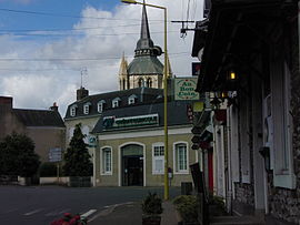
 The Avenue Charles de Gaulle, in Fresnay-sur-Sarthe | |
| Coordinates: 48°16′57″N 0°01′19″E / 48.2825°N 0.0219°E | |
| Country | France |
| Region | Pays de la Loire |
| Department | Sarthe |
| Arrondissement | Mamers |
| Canton | Sillé-le-Guillaume |
| Intercommunality | Haute Sarthe Alpes Mancelles |
| Area 1 | 29.20 km2 (11.27 sq mi) |
| Population (2021)[1] | 2,889 |
| • Density | 99/km2 (260/sq mi) |
| Demonym | Fresnois |
| Time zone | UTC+01:00 (CET) |
| • Summer (DST) | UTC+02:00 (CEST) |
| INSEE/Postal code | 72138 /72130 |
| Elevation | 62–117 m (203–384 ft) |
| 1 French Land Register data, which excludes lakes, ponds, glaciers > 1 km2 (0.386 sq mi or 247 acres) and river estuaries. | |
Fresnay-sur-Sarthe (French pronunciation: [fʁɛnɛ syʁ saʁt], literally Fresnay on Sarthe) is a commune in the Sarthe department in the region of Pays de la Loire in north-western France. On 1 January 2019, the former communes Coulombiers and Saint-Germain-sur-Sarthe were merged into Fresnay-sur-Sarthe.[2] Fresnay-sur-Sarthe is the seat of the communauté de communes Haute Sarthe Alpes Mancelles, which covers 38 communes with a total population of about 23,000.[3]
- ^ "Populations légales 2021" (in French). The National Institute of Statistics and Economic Studies. 28 December 2023.
- ^ Arrêté préfectoral 30 November 2018 (in French)
- ^ CC Haute Sarthe Alpes Mancelles, BANATIC database. Retrieved 9 November 2023.


