Back Fruitvale (lungsod sa Kanada) CEB Fruitvale (British Columbia) German Fruitvale (Canada) Italian Fruitvale, British Columbia Swedish Фрутвейл (Британська Колумбія) Ukrainian
Fruitvale | |
|---|---|
| The Corporation of the Village of Fruitvale[1] | |
 Main Street, Fruitvale | |
| Motto: The Heart of the Beaver Valley | |
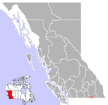
 Location of Fruitvale in British Columbia | |
| Coordinates: 49°06′56″N 117°32′43″W / 49.11556°N 117.54528°W | |
| Country | Canada |
| Province | British Columbia |
| Region | Kootenays |
| Regional district | Kootenay Boundary |
| Founded | 1907 |
| Incorporated | 1952 |
| Government | |
| • Governing body | Fruitvale Village Council |
| • Mayor | TBD |
| Area | |
| • Village | 6.01 km2 (2.32[4] sq mi) |
| • Urban | 2.70 km2 (1.04[5] sq mi) |
| Elevation | 681 m (2,234 ft) |
| Population (2021) | |
| • Village | 1,958[2] |
| Time zone | UTC-8 (PST) |
| Highways | |
| Waterways | Beaver Creek |
| Website | Village of Fruitvale |

Fruitvale is a village in the West Kootenay region of southeastern British Columbia. It is 16 km (9.9 mi) east of the city of Trail along Highway 3B.
- ^ "British Columbia Regional Districts, Municipalities, Corporate Name, Date of Incorporation and Postal Address" (XLS). British Columbia Ministry of Communities, Sport and Cultural Development. Archived from the original on July 13, 2014. Retrieved November 2, 2014.
- ^ "Profile table, Census Profile, 2021 Census of Population - Canada [Country]". 9 February 2022.
- ^ Mayor’s Welcome | Village of Fruitvale
- ^ "Census Profile, 2016 Census: Fruitvale, Retired population centre [Designated place]". Statistics Canada. 8 February 2017. Retrieved 13 December 2020.
- ^ "Census Profile, 2016 Census: Fruitvale, Village [Census subdivision]". Statistics Canada. 8 February 2017. Retrieved 13 December 2020.
- ^ "Fruitvale British Columbia - Wolfram|Alpha".