Back فوجا (جزيره) ARZ Illa Fuga Catalan Fuga Island (pulo sa Pilipinas) CEB Fuga Island German Isla Fuga Spanish Isla Fuga ILO Fuga (isola) Italian フガ島 Japanese Fuga (eiland) Dutch Pulo ng Fuga Tagalog
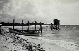
 Fuga Island tide gauge in 1927 | |
| Geography | |
|---|---|
| Coordinates | 18°52′21″N 121°22′44″E / 18.87250°N 121.37889°E |
| Archipelago | Babuyan Islands |
| Adjacent to | Babuyan Channel |
| Area | 97.1 km2 (37.5 sq mi)[1] |
| Highest elevation | 191 m (627 ft)[2] |
| Highest point | Mount Nanguringan |
| Administration | |
| Region | Cagayan Valley |
| Province | Cagayan |
| Municipality | Aparri |
| Demographics | |
| Population | 1,939 (2020)[3] |
| Pop. density | 20/km2 (50/sq mi) |
| Additional information | |
 | |
Fuga Island is an island and barangay located north of Luzon and is part of the Babuyan Islands, which is the second-northernmost island group of the Philippines. Barangay Fuga Island is one of the 42 barangays under the jurisdiction of the municipality of Aparri in the province of Cagayan.
- ^ Genevieve Broad; Carl Oliveros. "Biodiversity and conservation priority setting in the Babuyan Islands, Philippines" (PDF). The Technical Journal of Philippine Ecosystems and Natural Resources. 15 (1–2): 1–30. Retrieved 18 April 2018.
- ^ Cite error: The named reference
mapwas invoked but never defined (see the help page). - ^ Census of Population (2020). "Region II (Cagayan Valley)". Total Population by Province, City, Municipality and Barangay. Philippine Statistics Authority. Retrieved 8 July 2021.
