Back Gabriola Island CEB Gabriola Island German Insulo Gabriola Esperanto Isla Gabriola Spanish Île Gabriola French Isola Gabriola Italian Gabriola Island Swedish
Gabriola Island | |
|---|---|
Island | |
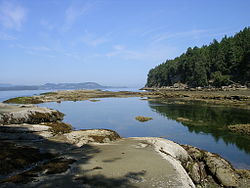
 Beach at Descanso Bay | |
| Gabriola in the southern Gulf Islands | |
Location of Gabriola, near Vancouver Island | |
| Coordinates: 49°9′0″N 123°43′58.8″W / 49.15000°N 123.733000°W | |
| Country | Canada |
| Province | British Columbia |
| Regional district | Nanaimo |
| Area | |
| • Total | 57.6 km2 (22.2 sq mi) |
| Population (2021) | |
| • Total | 4,500 |
| • Density | 78.1/km2 (202/sq mi) |
| Time zone | UTC−8 (Pacific Time Zone) |
| • Summer (DST) | UTC−7 (Pacific Daylight Time) |
| Postal code span | V0R |
| Area code | 250 |
Gabriola Island is one of the Gulf Islands in the Strait of Georgia in British Columbia (BC), Canada. It is about 5 kilometres (3.1 mi) east of Nanaimo on Vancouver Island, to which it is linked by a 20-minute ferry service. It has a land area of about 57.6 square kilometres (22.2 sq mi) and a resident population of 4,500.[1]
Gabriola has public beaches and forests, shopping centres, restaurants, a library, an elementary school and a museum. It is known as the Isle of the Arts due to its high percentage of working artists, and its many cultural events include annual festivals related to art, poetry, gardens, music, boating and fishing. The Gabriola Arts Council produces three large annual events: the Isle of the Arts Festival (April), Cultivate Arts Festival (Summer) and Thanksgiving Studio Tour (October).
- ^ "Profile table, Census Profile, 2021 Census of Population – Gabriola Island Trust Area, Island trust (IST) [Designated place], British Columbia". Statistics Canada. Government of Canada. 9 February 2022. Retrieved 30 June 2022.


