Back الجاليكيه ماسيف ARZ Massís Galaico Catalan Galicijský masiv Czech Macizo Galaico-Leonés Spanish Galizia-Leongo mendigunea Basque Massif galicien French Macizo Galaico Galician Masyw Galicyjski Polish Галісійський масив Ukrainian 加利西亞山脈 Chinese
| Galician Massif | |
|---|---|
| Macizo Galaico Macizo Galaico-Leonés | |
 | |
| Highest point | |
| Peak | Peña Trevinca |
| Elevation | 2,124 m (6,969 ft) |
| Coordinates | 42°14′33″N 6°47′45″W / 42.24250°N 6.79583°W |
| Geography | |
| Country | Spain |
| Autonomous Communities | Galicia and Castile and León |
| Range coordinates | 42°30′N 8°6′W / 42.500°N 8.100°W |
| Geology | |
| Orogeny | Variscan orogeny |
| Age of rock | Paleozoic |
| Type of rock | Schist, gneiss and granite |
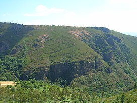
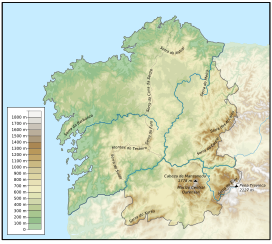
The Galician Massif or Galician-Leonese Massif (Spanish: Macizo Galaico, also known as Macizo Galaico-Leonés) is a system of mountain ranges in the northwestern corner of the Iberian Peninsula. It is located in Galicia with its southeastern end reaching into the provinces of Zamora and León of Castile and León. Its highest point is Pena Trevinca at 2,127 metres (6,978 ft) . Another important peak is Cabeza de Manzaneda (1,781 m).
In traditional local folklore the forests of the Galician System are said to be inhabited by a variety of elves, fairies, ghosts, the Santa Compaña, the Nubeiro and witches (meigas).
