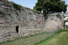
 The southern wall of the enclosure and the Petit-Cupidon tower in the background. | |
 | |
| 47°23′42″N 0°41′40″E / 47.39500°N 0.69444°E | |
| Location | Tours, Touraine, Indre-et-Loire, France |
|---|---|
| Type | Fortified enclosure |
| Completion date | 4th century |
| Partially listed as MH (1927)[1] | |
The Gallo-Roman enclosure of Tours is a wall surrounding the city of Civitas Turonorum (the cathedral quarter of the current city of Tours) and was constructed during the Late Roman Empire. It is commonly referred to as the "castrum enclosure." Only the remaining Gallo-Roman construction in Tours is accessible to the public. The enclosure has been designated a historical monument since 1927.
The structure was erected in the early years of the 4th century in the northeastern sector of the open city that had been established during the High Empire era. This construction was undertaken in response to the prevailing insecurity experienced in Gaul during this period. Many other cities subsequently adopted similar defensive measures. However, the implementation of this particular structure was not carried out hastily. This enclosure, which had a perimeter of 1,245 meters, was constructed using recycled materials sourced from existing buildings. The structure was supported by the amphitheater of Tours, which was converted into a monumental gate in the south of the new city. Approximately fifteen towers reinforced it, and several gates and posterns pierced it. The Loire River bathed its northern wall. When Tours expanded and built new enclosures in the 12th century and two centuries later, the castrum wall served as the base for the eastern part of the new constructions.
The meticulous archaeological excavations conducted from 1974 to 1978 on the site of the Tours castle (referred to as "site 3" by archaeologists) were followed by exhaustive studies in the early 1980s. These studies were completed at the end of the 20th century and the beginning of the 21st century, providing a comprehensive understanding of the architectural features of the site. However, considerable uncertainty persists regarding the structuring of space within the Cité, the nine hectares enclosed by the enclosure, and the number and social characteristics of its residents. A hypothesis is emerging that sees the northern half of the space inhabited by "civilians", including representatives of the administrative authority, while the southern half was reserved for religious individuals around the episcopal pole. It seems reasonable to posit that the city of Tours of the Late Empire did not confine itself to this fortified enclosure. However, the organization of the space outside the walls remains shrouded in obscurity.
- ^ "Enceinte romaine". Notice No. IA00071353, on the open heritage platform, Mérimée database, French Ministry of Culture. (in French). Archived from the original on 5 February 2024. Retrieved 2 July 2024.
{{cite web}}: CS1 maint: bot: original URL status unknown (link)
