Back Tuinring Afrikaans Sadovoje kolco Czech Сад унки CV Haveringen Danish Gartenring German Ĝardena ringo (Moskvo) Esperanto Puutarhakehä Finnish Ceinture des Jardins French טבעת הגנים HE Anello dei giardini Italian
You can help expand this article with text translated from the corresponding article in Russian. (February 2013) Click [show] for important translation instructions.
|


The Garden Ring, also known as the "B" Ring (Russian: Садо́вое кольцо́, кольцо́ "Б"; transliteration: Sadovoye Koltso), is a circular ring road avenue around central Moscow, its course corresponding to what used to be the city ramparts surrounding Zemlyanoy Gorod in the 17th century.
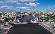
The Ring consists of seventeen individually named streets[1] and fifteen squares. It has a circumference of 16 kilometers (9.9 mi).[2] At its narrowest point, Krymsky Bridge, the Ring has six lanes. After finishing reconstruction, all sections of the Ring will not have more than 10 lanes. In 2018, more than 50 % of sections of the Garden Ring are reconstructed, including Zubovskaya square, which was the widest section, there were about 18 lanes before. The Ring emerged in the 1820s, replacing fortifications, in the form of ramparts, that were no longer of military value.
- ^ Two of these streets, Korovy Val and Zhitnaya Street, are parallel frontage roads that run along the same stretch of the Ring in a tunnel.
- ^ Russian: Энциклопедия "Москва", 1997