Back مقاطعة غاريت (ماريلاند) Arabic Garrett County, Maryland BAR Гарет (окръг, Мериленд) Bulgarian গারেট কাউন্টি, মেরিল্যান্ড BPY Garrett Gông (Maryland) CDO Гарретт (гуо, Мэриленд) CE Garrett County CEB Garrett County, Maryland Welsh Garrett County German Condado de Garrett Spanish
Garrett County | |
|---|---|
 Garrett County Courthouse in December 2013 | |
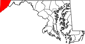
 Location within the U.S. state of Maryland | |
 Maryland's location within the U.S. | |
| Coordinates: 39°17′N 79°22′W / 39.28°N 79.37°W | |
| Country | |
| State | |
| Founded | November 4, 1872 |
| Named for | John Work Garrett |
| Seat | Oakland |
| Largest town | Mountain Lake Park |
| Area | |
| • Total | 656 sq mi (1,700 km2) |
| • Land | 647 sq mi (1,680 km2) |
| • Water | 8.6 sq mi (22 km2) 1.3% |
| Population (2020) | |
| • Total | 28,806 |
| • Estimate (2023) | 28,423 |
| • Density | 44/sq mi (17/km2) |
| Time zone | UTC−5 (Eastern) |
| • Summer (DST) | UTC−4 (EDT) |
| Congressional district | 6th |
| Website | www |

Garrett County (/ɡərɛt/) is the westernmost county of the U.S. state of Maryland completely within the Appalachian Mountains. As of the 2020 census, the population was 28,806,[1] making it the third-least populous county in Maryland. Its county seat is Oakland.[2] The county was named for John Work Garrett (1820–1884), president of the Baltimore and Ohio Railroad.[3] Created from Allegany County in 1872, it was the last county to be formed in the state. The county is part of the Western Maryland region of the state. Garrett County is bordered by four West Virginia counties and to the north the Maryland–Pennsylvania boundary known as the Mason–Dixon line.[4] The eastern border with Allegany County was defined by the Bauer Report, submitted to Governor Lloyd Lowndes, Jr. on November 9, 1898.[5] The Potomac River and State of West Virginia lie to the south and west.
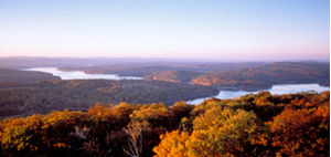
Garrett County lies in the Allegheny Mountains, which here form the western flank of the Appalachian Mountain Range. Hoye-Crest, a summit along Backbone Mountain, is the highest point in Maryland at an elevation of 3,360 feet (1,020 m).[6]
The Eastern Continental Divide runs along portions of Backbone Mountain. The western part of the county, drained by the Youghiogheny River, is the only part of Maryland within the Mississippi River drainage basin. All other parts of the county are in the Chesapeake Bay basin.
The National Register of Historic Places listings in Garrett County, Maryland has 20 National Register of Historic Places[7] properties and districts, including Casselman Bridge, National Road a National Historic Landmark. Garrett County is part of Maryland's 6th congressional district. The extreme south of the county lies within the United States National Radio Quiet Zone.
- ^ "Census: Garrett County population down 4.3 percent". Garrett County Republican. August 19, 2021.
- ^ "Find a County". National Association of Counties. Archived from the original on May 31, 2011. Retrieved June 7, 2011.
- ^ "Maryland Counties, Garrett County, Maryland". Maryland Manual On-Line. Maryland State Archives. Archived from the original on June 14, 2021. Retrieved November 11, 2009.
- ^ Cope, Thomas D (May 1949), "Degrees along the west line, the parallel between Maryland and Pennsylvania", Proceedings of the American Philosophical Society, 93 (2), American Philosophical Society: 127–133, JSTOR 3143431
- ^ "Title 1: General Provisions". Garrett County, MD Code of Ordinances. American Legal Publishing Corporation. Archived from the original on October 31, 2009. Retrieved November 11, 2009.
- ^ "Hoye-Crest | Maryland". peakery.com. Retrieved October 10, 2021.
- ^ "National Register Information System". National Register of Historic Places. National Park Service. April 15, 2008.

