Back Geitungen fyr Danish Phare de Geitungen French Geitungen fyrstasjon NN Geitungen fyr NB Geitungen fyr Swedish
 Geitungen Lighthouse | |
 | |
| Location | Karmøy Rogaland Norway |
|---|---|
| Coordinates | 59°07′53″N 05°14′34″E / 59.13139°N 5.24278°E |
| Tower | |
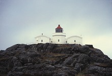
| Constructed | 1924 |
| Construction | masonry tower |
| Automated | 1994 |
| Height | 11.2 metres (37 ft) |
| Shape | octagonal tower |
| Markings | white tower, red lantern roof |
| Operator | Haugesund Turistforening |
| Heritage | cultural property |
| Racon | G |
| Light | |
| Focal height | 41 metres (135 ft) |
| Range | 17 nmi (31 km; 20 mi) |
| Characteristic | Oc WRG 6s. |
| Norway no. | 126500 |
Geitungen Lighthouse (Norwegian: Geitungen fyr) is a coastal lighthouse in the municipality of Karmøy in Rogaland county, Norway. The lighthouse is located on a small island about 1 kilometre (0.62 mi) off the southern tip of the main island of Karmøy. The entrance to the harbor of the town of Skudeneshavn lies about 3 kilometres (1.9 mi) northeast of the lighthouse. The island is accessible only by boat. The lighthouse was established in 1924 and it was automated in 1994. It was listed as a protected site in 1998.[1][2]
- ^ Godal, Anne Marit (ed.). "Geitungen fyr". Store norske leksikon (in Norwegian). Norsk nettleksikon. Retrieved 5 February 2012.
- ^ "Geitungen fyrstasjon" (in Norwegian). Norsk Fyrhistorisk Forening. Retrieved 5 February 2012.