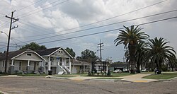
Gentilly | |
|---|---|
 Gentilly "Sugar Hill" section, New Orleans | |
| Coordinates: 30°00′45″N 90°03′37″W / 30.0125°N 90.0603°W | |
| Country | United States |
| State | Louisiana |
| City | New Orleans |
| Government | |
| • Mayor | LaToya Cantrell |
| Time zone | UTC-6 (CST) |
| • Summer (DST) | UTC-5 (CDT) |
| Area code | 504 |
Gentilly is a broad, predominantly middle-class and racially diverse section of New Orleans, Louisiana. The Gentilly neighborhood is bounded by Lake Pontchartrain to the north, France Road to the east, Bayou St. John to the west, and CSX Transportation railroad tracks to the south.
The major north-south streets are Franklin Avenue, Elysian Fields Avenue, St. Anthony, St. Bernard, St. Roch, Paris, Wisner, A.P. Tureaud (formerly London) Avenue and Press. The east-west streets are Lakeshore Drive, Leon C. Simon, Allen Toussaint Blvd (a section of which was formerly called Hibernia), Prentiss, Harrison, Filmore, Mirabeau, Hayne, Chef Menteur, and Gentilly.
- ^ City Of New Orleans : City Charter Archived 2010-01-04 at the Wayback Machine

